You are here: Home > Network List > G - GEOSCOPE Stations List
> Station RER Riviere de l'Est, La Reunion (Indian Ocean) > Earthquake Result Viewer
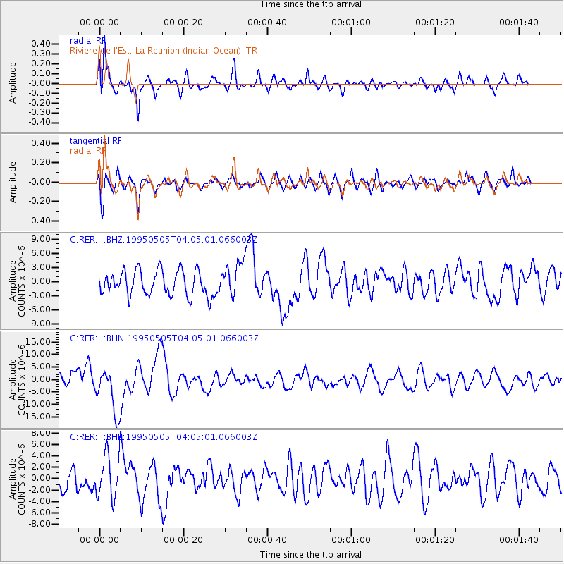
RER Riviere de l'Est, La Reunion (Indian Ocean) - Earthquake Result Viewer
*The percent match for this event was below the threshold and hence no stack was calculated.
| Earthquake location: |
Samar, Philippines |
| Earthquake latitude/longitude: |
12.6/125.3 |
| Earthquake time(UTC): |
1995/05/05 (125) 03:53:47 GMT |
| Earthquake Depth: |
33 km |
| Earthquake Magnitude: |
6.2 MB, 7.0 MS, 7.1 UNKNOWN, 7.0 MW |
| Earthquake Catalog/Contributor: |
WHDF/NEIC |
|
| Network: |
G GEOSCOPE |
| Station: |
RER Riviere de l'Est, La Reunion (Indian Ocean) |
| Lat/Lon: |
21.16 S/55.75 E |
| Elevation: |
834 m |
|
| Distance: |
76.1 deg |
| Az: |
244.295 deg |
| Baz: |
70.443 deg |
| Ray Param: |
$rayparam |
*The percent match for this event was below the threshold and hence was not used in the summary stack. |
|
| Radial Match: |
75.727295 % |
| Radial Bump: |
400 |
| Transverse Match: |
61.201603 % |
| Transverse Bump: |
400 |
| SOD ConfigId: |
4480 |
| Insert Time: |
2010-02-26 23:46:16.553 +0000 |
| GWidth: |
2.5 |
| Max Bumps: |
400 |
| Tol: |
0.001 |
|
Signal To Noise
| Channel | StoN | STA | LTA |
| G:RER: :BHN:19950505T04:05:01.066003Z | 5.008147 | 9.519997E-6 | 1.9009021E-6 |
| G:RER: :BHE:19950505T04:05:01.066003Z | 2.3913705 | 3.8918565E-6 | 1.6274586E-6 |
| G:RER: :BHZ:19950505T04:05:01.066003Z | 1.3673266 | 3.4251443E-6 | 2.5049935E-6 |
| Arrivals |
| Ps | |
| PpPs | |
| PsPs/PpSs | |


