You are here: Home > Network List > NN - Western Great Basin/Eastern Sierra Nevada Stations List
> Station RYN Ryan, Nevada w84,gps > Earthquake Result Viewer
RYN Ryan, Nevada w84,gps - Earthquake Result Viewer
| Earthquake location: |
E. Caroline Islands, Micronesia |
| Earthquake latitude/longitude: |
6.5/144.9 |
| Earthquake time(UTC): |
2014/05/15 (135) 08:16:34 GMT |
| Earthquake Depth: |
10 km |
| Earthquake Magnitude: |
6.6 MWP, 6.6 MI |
| Earthquake Catalog/Contributor: |
NEIC PDE/NEIC COMCAT |
|
| Network: |
NN Western Great Basin/Eastern Sierra Nevada |
| Station: |
RYN Ryan, Nevada w84,gps |
| Lat/Lon: |
38.63 N/118.52 W |
| Elevation: |
1651 m |
|
| Distance: |
91.1 deg |
| Az: |
51.1 deg |
| Baz: |
279.149 deg |
| Ray Param: |
0.04162636 |
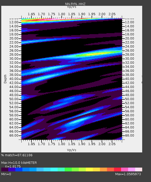
| Estimated Moho Depth: |
10.0 km |
| Estimated Crust Vp/Vs: |
1.82 |
| Assumed Crust Vp: |
6.279 km/s |
| Estimated Crust Vs: |
3.455 km/s |
| Estimated Crust Poisson's Ratio: |
0.28 |
|
| Radial Match: |
87.61186 % |
| Radial Bump: |
292 |
| Transverse Match: |
75.56565 % |
| Transverse Bump: |
354 |
| SOD ConfigId: |
3390531 |
| Insert Time: |
2019-04-11 21:34:14.179 +0000 |
| GWidth: |
2.5 |
| Max Bumps: |
400 |
| Tol: |
0.001 |
|

Signal To Noise
| Channel | StoN | STA | LTA |
| NN:RYN: :HHZ:20140515T08:29:08.280017Z | 1.9396886 | 1.01135434E-7 | 5.2140038E-8 |
| NN:RYN: :HHN:20140515T08:29:08.280017Z | 1.2749469 | 5.019862E-8 | 3.9373102E-8 |
| NN:RYN: :HHE:20140515T08:29:08.280017Z | 1.2986735 | 4.2670493E-8 | 3.285698E-8 |
| Arrivals |
| Ps | 1.3 SECOND |
| PpPs | 4.4 SECOND |
| PsPs/PpSs | 5.7 SECOND |


