You are here: Home > Network List > PS - Pacific21 Stations List
> Station PSI Parapat, Indonesia > Earthquake Result Viewer
PSI Parapat, Indonesia - Earthquake Result Viewer
| Earthquake location: |
E. Caroline Islands, Micronesia |
| Earthquake latitude/longitude: |
6.5/144.9 |
| Earthquake time(UTC): |
2014/05/15 (135) 08:16:34 GMT |
| Earthquake Depth: |
10 km |
| Earthquake Magnitude: |
6.6 MWP, 6.6 MI |
| Earthquake Catalog/Contributor: |
NEIC PDE/NEIC COMCAT |
|
| Network: |
PS Pacific21 |
| Station: |
PSI Parapat, Indonesia |
| Lat/Lon: |
2.69 N/98.92 E |
| Elevation: |
987 m |
|
| Distance: |
46.0 deg |
| Az: |
267.466 deg |
| Baz: |
83.591 deg |
| Ray Param: |
0.07093485 |
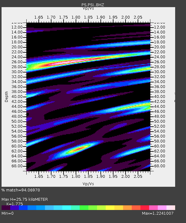
| Estimated Moho Depth: |
25.75 km |
| Estimated Crust Vp/Vs: |
1.77 |
| Assumed Crust Vp: |
6.468 km/s |
| Estimated Crust Vs: |
3.644 km/s |
| Estimated Crust Poisson's Ratio: |
0.27 |
|
| Radial Match: |
94.06978 % |
| Radial Bump: |
400 |
| Transverse Match: |
83.453255 % |
| Transverse Bump: |
400 |
| SOD ConfigId: |
3390531 |
| Insert Time: |
2019-04-11 21:34:33.572 +0000 |
| GWidth: |
2.5 |
| Max Bumps: |
400 |
| Tol: |
0.001 |
|
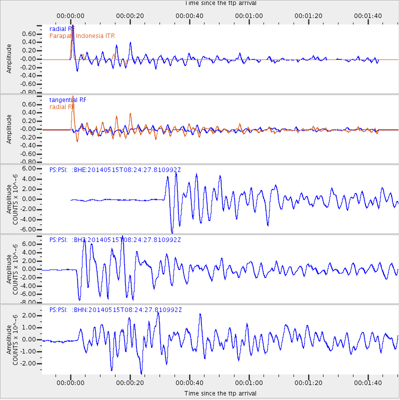
Signal To Noise
| Channel | StoN | STA | LTA |
| PS:PSI: :BHZ:20140515T08:24:27.810992Z | 46.399742 | 3.7210473E-6 | 8.019543E-8 |
| PS:PSI: :BHN:20140515T08:24:27.810992Z | 4.789928 | 3.8845283E-7 | 8.1097845E-8 |
| PS:PSI: :BHE:20140515T08:24:27.810992Z | 28.765125 | 2.5712288E-6 | 8.9387015E-8 |
| Arrivals |
| Ps | 3.3 SECOND |
| PpPs | 10 SECOND |
| PsPs/PpSs | 14 SECOND |


