You are here: Home > Network List > TA - USArray Transportable Network (new EarthScope stations) Stations List
> Station N02D Trinity Center, CA, USA > Earthquake Result Viewer
N02D Trinity Center, CA, USA - Earthquake Result Viewer
| Earthquake location: |
E. Caroline Islands, Micronesia |
| Earthquake latitude/longitude: |
6.5/144.9 |
| Earthquake time(UTC): |
2014/05/15 (135) 08:16:34 GMT |
| Earthquake Depth: |
10 km |
| Earthquake Magnitude: |
6.6 MWP, 6.6 MI |
| Earthquake Catalog/Contributor: |
NEIC PDE/NEIC COMCAT |
|
| Network: |
TA USArray Transportable Network (new EarthScope stations) |
| Station: |
N02D Trinity Center, CA, USA |
| Lat/Lon: |
40.97 N/122.71 W |
| Elevation: |
937 m |
|
| Distance: |
87.6 deg |
| Az: |
49.217 deg |
| Baz: |
276.459 deg |
| Ray Param: |
0.043219592 |
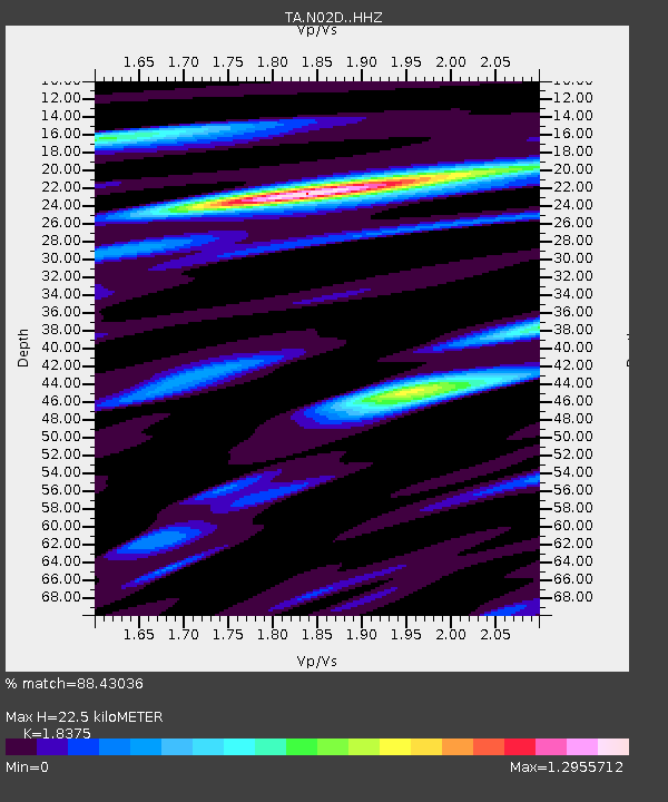
| Estimated Moho Depth: |
22.5 km |
| Estimated Crust Vp/Vs: |
1.84 |
| Assumed Crust Vp: |
6.566 km/s |
| Estimated Crust Vs: |
3.573 km/s |
| Estimated Crust Poisson's Ratio: |
0.29 |
|
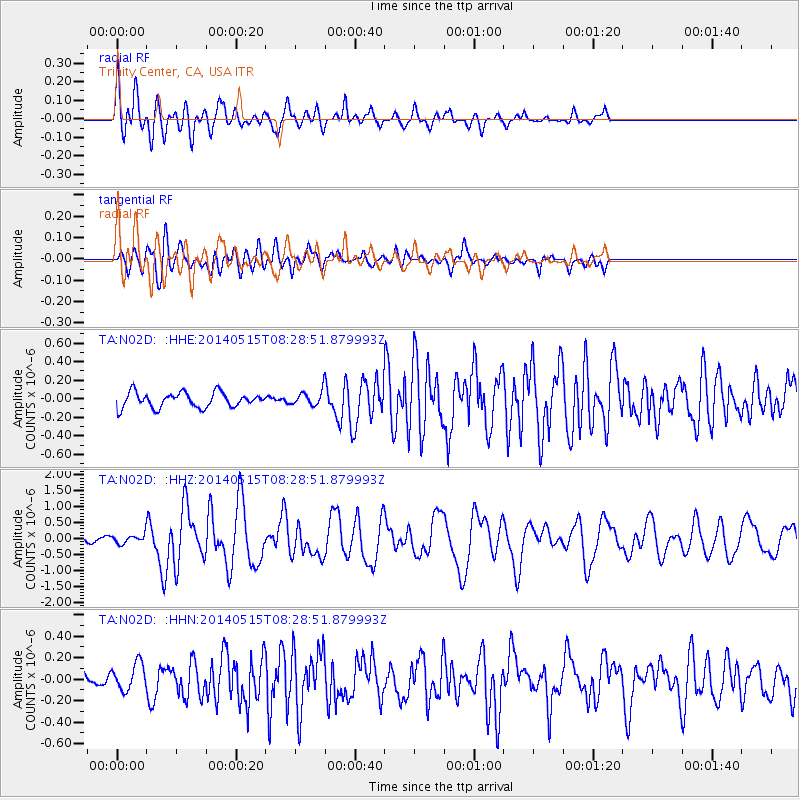
| Radial Match: |
88.43036 % |
| Radial Bump: |
400 |
| Transverse Match: |
76.23654 % |
| Transverse Bump: |
400 |
| SOD ConfigId: |
3390531 |
| Insert Time: |
2019-04-11 21:34:49.494 +0000 |
| GWidth: |
2.5 |
| Max Bumps: |
400 |
| Tol: |
0.001 |
|
Signal To Noise
| Channel | StoN | STA | LTA |
| TA:N02D: :HHZ:20140515T08:28:51.879993Z | 1.9556185 | 1.3692315E-7 | 7.001527E-8 |
| TA:N02D: :HHN:20140515T08:28:51.879993Z | 1.7270536 | 1.2775186E-7 | 7.397099E-8 |
| TA:N02D: :HHE:20140515T08:28:51.879993Z | 0.73976195 | 5.999194E-8 | 8.109628E-8 |
| Arrivals |
| Ps | 2.9 SECOND |
| PpPs | 9.5 SECOND |
| PsPs/PpSs | 12 SECOND |


