You are here: Home > Network List > NE - New England Seismic Network Stations List
> Station BRYW Smithfield, RI > Earthquake Result Viewer
BRYW Smithfield, RI - Earthquake Result Viewer
| Earthquake location: |
Santiago Del Estero Prov., Arg. |
| Earthquake latitude/longitude: |
-28.0/-63.1 |
| Earthquake time(UTC): |
2012/05/28 (149) 05:07:23 GMT |
| Earthquake Depth: |
587 km |
| Earthquake Magnitude: |
6.0 MB, 6.7 MW, 6.8 MW |
| Earthquake Catalog/Contributor: |
WHDF/NEIC |
|
| Network: |
NE New England Seismic Network |
| Station: |
BRYW Smithfield, RI |
| Lat/Lon: |
41.92 N/71.54 W |
| Elevation: |
107 m |
|
| Distance: |
70.0 deg |
| Az: |
353.305 deg |
| Baz: |
172.063 deg |
| Ray Param: |
0.05321159 |
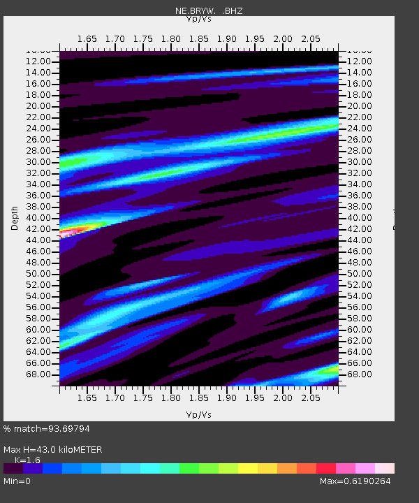
| Estimated Moho Depth: |
43.0 km |
| Estimated Crust Vp/Vs: |
1.60 |
| Assumed Crust Vp: |
6.472 km/s |
| Estimated Crust Vs: |
4.045 km/s |
| Estimated Crust Poisson's Ratio: |
0.18 |
|
| Radial Match: |
93.69794 % |
| Radial Bump: |
400 |
| Transverse Match: |
72.97342 % |
| Transverse Bump: |
400 |
| SOD ConfigId: |
455246 |
| Insert Time: |
2012-09-24 23:50:48.363 +0000 |
| GWidth: |
2.5 |
| Max Bumps: |
400 |
| Tol: |
0.001 |
|

Signal To Noise
| Channel | StoN | STA | LTA |
| NE:BRYW: :BHZ:20120528T05:17:06.309985Z | 22.28009 | 3.2999035E-6 | 1.4810996E-7 |
| NE:BRYW: :BHN:20120528T05:17:06.309985Z | 11.147442 | 1.6553869E-6 | 1.4849925E-7 |
| NE:BRYW: :BHE:20120528T05:17:06.309985Z | 1.3526849 | 1.9030398E-7 | 1.4068613E-7 |
| Arrivals |
| Ps | 4.1 SECOND |
| PpPs | 17 SECOND |
| PsPs/PpSs | 21 SECOND |


