You are here: Home > Network List > PM - Portuguese National Seismic Network Stations List
> Station PFVI PM.PFVI > Earthquake Result Viewer
PFVI PM.PFVI - Earthquake Result Viewer
| Earthquake location: |
Santiago Del Estero Prov., Arg. |
| Earthquake latitude/longitude: |
-28.0/-63.1 |
| Earthquake time(UTC): |
2012/05/28 (149) 05:07:23 GMT |
| Earthquake Depth: |
587 km |
| Earthquake Magnitude: |
6.0 MB, 6.7 MW, 6.8 MW |
| Earthquake Catalog/Contributor: |
WHDF/NEIC |
|
| Network: |
PM Portuguese National Seismic Network |
| Station: |
PFVI PM.PFVI |
| Lat/Lon: |
37.13 N/8.83 W |
| Elevation: |
189 m |
|
| Distance: |
82.4 deg |
| Az: |
40.875 deg |
| Baz: |
226.368 deg |
| Ray Param: |
0.045121957 |
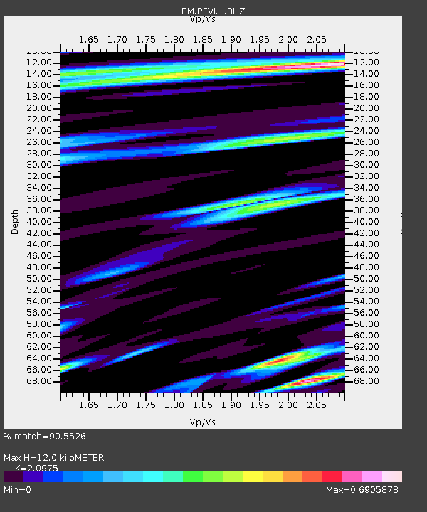
| Estimated Moho Depth: |
12.0 km |
| Estimated Crust Vp/Vs: |
2.10 |
| Assumed Crust Vp: |
6.048 km/s |
| Estimated Crust Vs: |
2.883 km/s |
| Estimated Crust Poisson's Ratio: |
0.35 |
|
| Radial Match: |
90.5526 % |
| Radial Bump: |
400 |
| Transverse Match: |
78.64998 % |
| Transverse Bump: |
400 |
| SOD ConfigId: |
455246 |
| Insert Time: |
2012-09-24 23:52:47.392 +0000 |
| GWidth: |
2.5 |
| Max Bumps: |
400 |
| Tol: |
0.001 |
|

Signal To Noise
| Channel | StoN | STA | LTA |
| PM:PFVI: :BHZ:20120528T05:18:13.984973Z | 21.498835 | 5.1010034E-6 | 2.3726884E-7 |
| PM:PFVI: :BHN:20120528T05:18:13.984973Z | 8.000361 | 1.3501764E-6 | 1.6876443E-7 |
| PM:PFVI: :BHE:20120528T05:18:14.015002Z | 3.5611534 | 8.6013705E-7 | 2.415333E-7 |
| Arrivals |
| Ps | 2.2 SECOND |
| PpPs | 6.0 SECOND |
| PsPs/PpSs | 8.3 SECOND |


