You are here: Home > Network List > G - GEOSCOPE Stations List
> Station RER Riviere de l'Est, La Reunion (Indian Ocean) > Earthquake Result Viewer
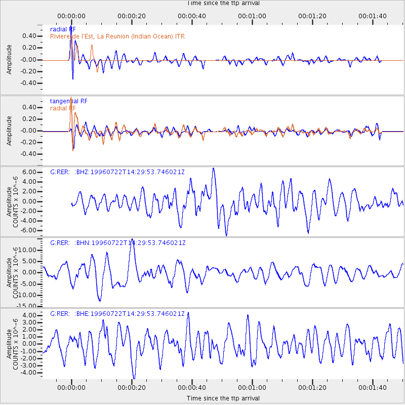
RER Riviere de l'Est, La Reunion (Indian Ocean) - Earthquake Result Viewer
*The percent match for this event was below the threshold and hence no stack was calculated.
| Earthquake location: |
Minahassa Peninsula, Sulawesi |
| Earthquake latitude/longitude: |
1.0/120.4 |
| Earthquake time(UTC): |
1996/07/22 (204) 14:19:35 GMT |
| Earthquake Depth: |
33 km |
| Earthquake Magnitude: |
6.0 MB, 6.9 MS, 7.0 UNKNOWN, 6.9 MW |
| Earthquake Catalog/Contributor: |
WHDF/NEIC |
|
| Network: |
G GEOSCOPE |
| Station: |
RER Riviere de l'Est, La Reunion (Indian Ocean) |
| Lat/Lon: |
21.16 S/55.75 E |
| Elevation: |
834 m |
|
| Distance: |
66.9 deg |
| Az: |
246.57 deg |
| Baz: |
79.38 deg |
| Ray Param: |
$rayparam |
*The percent match for this event was below the threshold and hence was not used in the summary stack. |
|
| Radial Match: |
67.56171 % |
| Radial Bump: |
400 |
| Transverse Match: |
58.06733 % |
| Transverse Bump: |
400 |
| SOD ConfigId: |
4480 |
| Insert Time: |
2010-02-26 23:46:41.359 +0000 |
| GWidth: |
2.5 |
| Max Bumps: |
400 |
| Tol: |
0.001 |
|
Signal To Noise
| Channel | StoN | STA | LTA |
| G:RER: :BHN:19960722T14:29:53.746021Z | 2.376493 | 3.5141998E-6 | 1.4787335E-6 |
| G:RER: :BHE:19960722T14:29:53.746021Z | 0.9619808 | 1.1517135E-6 | 1.1972312E-6 |
| G:RER: :BHZ:19960722T14:29:53.746021Z | 1.1649972 | 1.3987061E-6 | 1.2006091E-6 |
| Arrivals |
| Ps | |
| PpPs | |
| PsPs/PpSs | |


