You are here: Home > Network List > TA - USArray Transportable Network (new EarthScope stations) Stations List
> Station 833A Chaparral WMA, Artesia Wells, TX, USA > Earthquake Result Viewer
833A Chaparral WMA, Artesia Wells, TX, USA - Earthquake Result Viewer
| Earthquake location: |
Santiago Del Estero Prov., Arg. |
| Earthquake latitude/longitude: |
-28.0/-63.1 |
| Earthquake time(UTC): |
2012/05/28 (149) 05:07:23 GMT |
| Earthquake Depth: |
587 km |
| Earthquake Magnitude: |
6.0 MB, 6.7 MW, 6.8 MW |
| Earthquake Catalog/Contributor: |
WHDF/NEIC |
|
| Network: |
TA USArray Transportable Network (new EarthScope stations) |
| Station: |
833A Chaparral WMA, Artesia Wells, TX, USA |
| Lat/Lon: |
28.32 N/99.39 W |
| Elevation: |
171 m |
|
| Distance: |
66.0 deg |
| Az: |
325.147 deg |
| Baz: |
145.044 deg |
| Ray Param: |
0.055774774 |
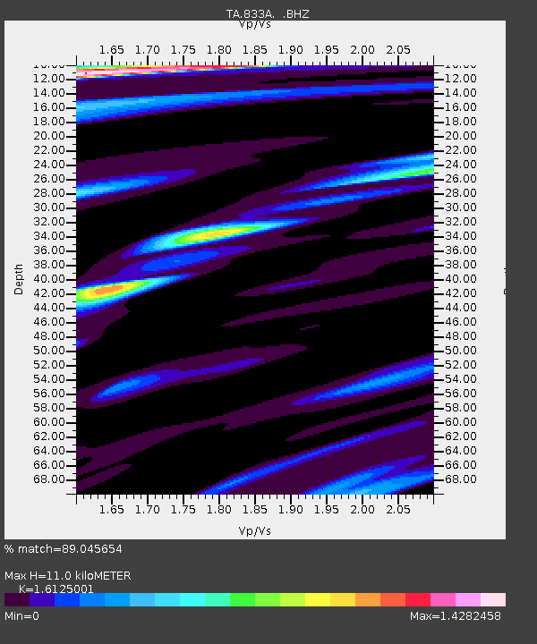
| Estimated Moho Depth: |
11.0 km |
| Estimated Crust Vp/Vs: |
1.61 |
| Assumed Crust Vp: |
6.347 km/s |
| Estimated Crust Vs: |
3.936 km/s |
| Estimated Crust Poisson's Ratio: |
0.19 |
|
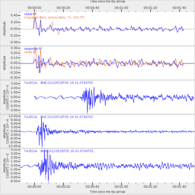
| Radial Match: |
89.045654 % |
| Radial Bump: |
400 |
| Transverse Match: |
76.93526 % |
| Transverse Bump: |
400 |
| SOD ConfigId: |
455246 |
| Insert Time: |
2012-09-24 23:56:19.341 +0000 |
| GWidth: |
2.5 |
| Max Bumps: |
400 |
| Tol: |
0.001 |
|
Signal To Noise
| Channel | StoN | STA | LTA |
| TA:833A: :BHZ:20120528T05:16:41.674976Z | 15.210052 | 3.2209005E-6 | 2.1176132E-7 |
| TA:833A: :BHN:20120528T05:16:41.674976Z | 4.131599 | 6.9295123E-7 | 1.6771989E-7 |
| TA:833A: :BHE:20120528T05:16:41.674976Z | 2.6059988 | 4.5885943E-7 | 1.7607815E-7 |
| Arrivals |
| Ps | 1.1 SECOND |
| PpPs | 4.3 SECOND |
| PsPs/PpSs | 5.5 SECOND |


