You are here: Home > Network List > TA - USArray Transportable Network (new EarthScope stations) Stations List
> Station B32A Ashes, Strandquist, MN, USA > Earthquake Result Viewer
B32A Ashes, Strandquist, MN, USA - Earthquake Result Viewer
| Earthquake location: |
Santiago Del Estero Prov., Arg. |
| Earthquake latitude/longitude: |
-28.0/-63.1 |
| Earthquake time(UTC): |
2012/05/28 (149) 05:07:23 GMT |
| Earthquake Depth: |
587 km |
| Earthquake Magnitude: |
6.0 MB, 6.7 MW, 6.8 MW |
| Earthquake Catalog/Contributor: |
WHDF/NEIC |
|
| Network: |
TA USArray Transportable Network (new EarthScope stations) |
| Station: |
B32A Ashes, Strandquist, MN, USA |
| Lat/Lon: |
48.40 N/96.54 W |
| Elevation: |
335 m |
|
| Distance: |
81.8 deg |
| Az: |
338.216 deg |
| Baz: |
150.517 deg |
| Ray Param: |
0.045576833 |
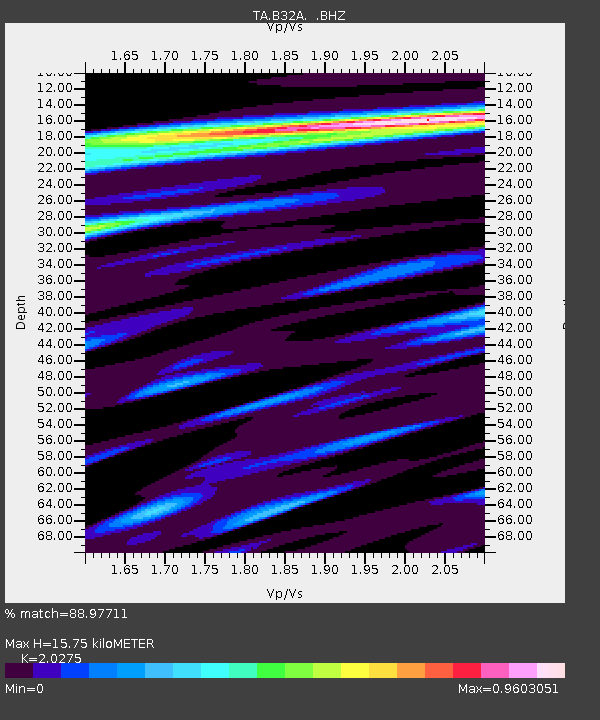
| Estimated Moho Depth: |
15.75 km |
| Estimated Crust Vp/Vs: |
2.03 |
| Assumed Crust Vp: |
6.498 km/s |
| Estimated Crust Vs: |
3.205 km/s |
| Estimated Crust Poisson's Ratio: |
0.34 |
|
| Radial Match: |
88.97711 % |
| Radial Bump: |
400 |
| Transverse Match: |
70.398186 % |
| Transverse Bump: |
400 |
| SOD ConfigId: |
455246 |
| Insert Time: |
2012-09-24 23:57:53.176 +0000 |
| GWidth: |
2.5 |
| Max Bumps: |
400 |
| Tol: |
0.001 |
|
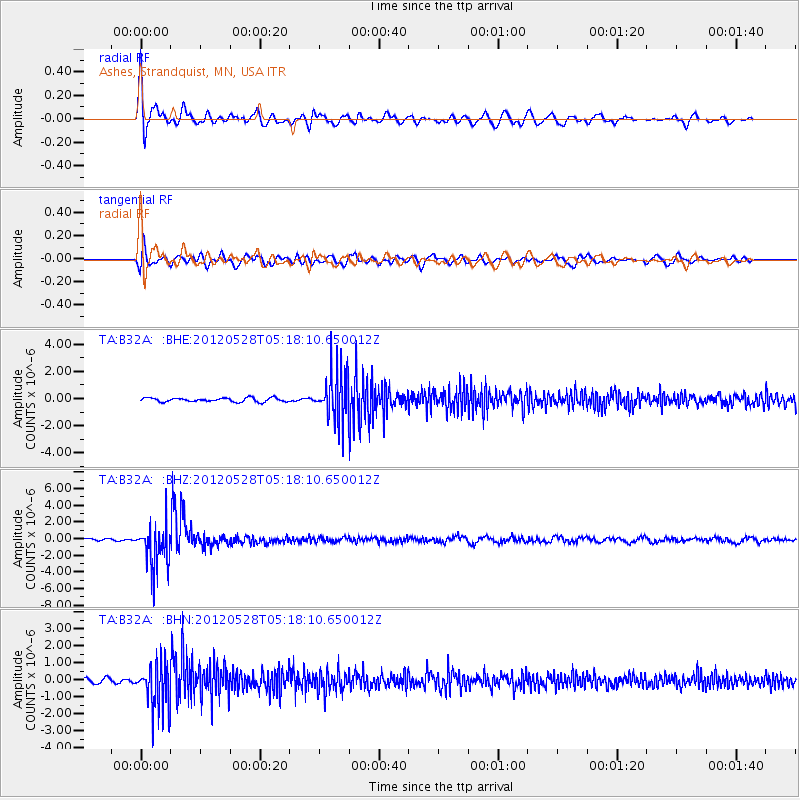
Signal To Noise
| Channel | StoN | STA | LTA |
| TA:B32A: :BHZ:20120528T05:18:10.650012Z | 12.668317 | 2.5260365E-6 | 1.9939796E-7 |
| TA:B32A: :BHN:20120528T05:18:10.650012Z | 12.119907 | 1.3296248E-6 | 1.09705844E-7 |
| TA:B32A: :BHE:20120528T05:18:10.650012Z | 13.042687 | 1.8337533E-6 | 1.4059628E-7 |
| Arrivals |
| Ps | 2.5 SECOND |
| PpPs | 7.2 SECOND |
| PsPs/PpSs | 9.7 SECOND |


