You are here: Home > Network List > G - GEOSCOPE Stations List
> Station RER Riviere de l'Est, La Reunion (Indian Ocean) > Earthquake Result Viewer
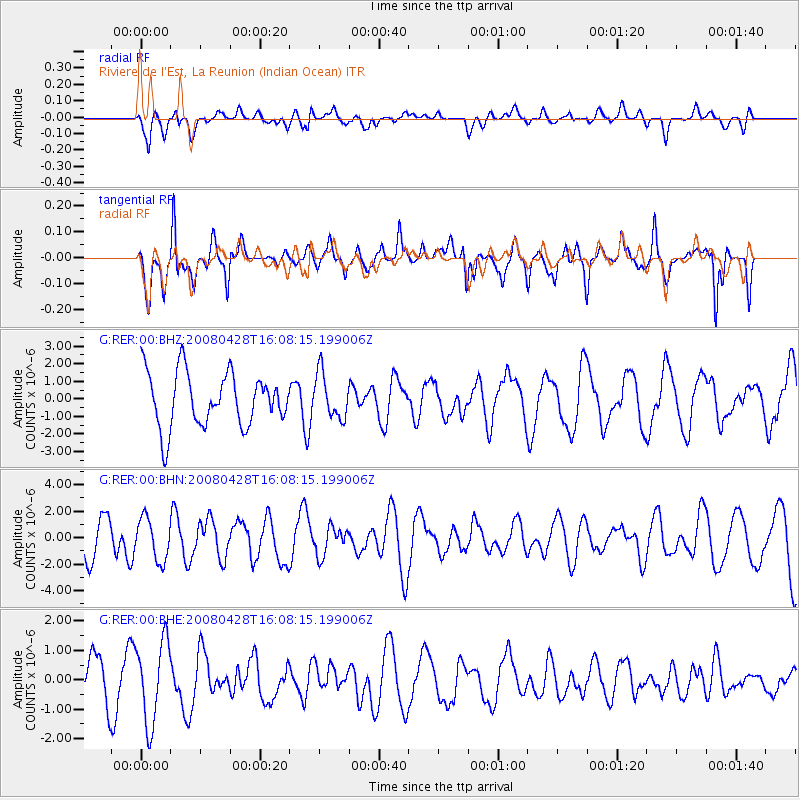
RER Riviere de l'Est, La Reunion (Indian Ocean) - Earthquake Result Viewer
*The percent match for this event was below the threshold and hence no stack was calculated.
| Earthquake location: |
South Sandwich Islands Region |
| Earthquake latitude/longitude: |
-58.7/-24.7 |
| Earthquake time(UTC): |
2008/04/28 (119) 15:57:55 GMT |
| Earthquake Depth: |
35 km |
| Earthquake Magnitude: |
5.5 MB, 5.9 MS, 6.1 MW, 6.0 MW |
| Earthquake Catalog/Contributor: |
WHDF/NEIC |
|
| Network: |
G GEOSCOPE |
| Station: |
RER Riviere de l'Est, La Reunion (Indian Ocean) |
| Lat/Lon: |
21.16 S/55.75 E |
| Elevation: |
834 m |
|
| Distance: |
67.2 deg |
| Az: |
93.428 deg |
| Baz: |
213.897 deg |
| Ray Param: |
$rayparam |
*The percent match for this event was below the threshold and hence was not used in the summary stack. |
|
| Radial Match: |
43.595757 % |
| Radial Bump: |
400 |
| Transverse Match: |
51.20226 % |
| Transverse Bump: |
365 |
| SOD ConfigId: |
2504 |
| Insert Time: |
2010-02-26 23:46:48.238 +0000 |
| GWidth: |
2.5 |
| Max Bumps: |
400 |
| Tol: |
0.001 |
|
Signal To Noise
| Channel | StoN | STA | LTA |
| G:RER:00:BHN:20080428T16:08:15.199006Z | 0.9127311 | 1.5903767E-6 | 1.7424372E-6 |
| G:RER:00:BHE:20080428T16:08:15.199006Z | 2.4241877 | 1.3897854E-6 | 5.732994E-7 |
| G:RER:00:BHZ:20080428T16:08:15.199006Z | 0.84327877 | 1.2922047E-6 | 1.5323576E-6 |
| Arrivals |
| Ps | |
| PpPs | |
| PsPs/PpSs | |


