You are here: Home > Network List > TA - USArray Transportable Network (new EarthScope stations) Stations List
> Station D34A Park Rapids, MN, USA > Earthquake Result Viewer
D34A Park Rapids, MN, USA - Earthquake Result Viewer

| Earthquake location: |
Santiago Del Estero Prov., Arg. |
| Earthquake latitude/longitude: |
-28.0/-63.1 |
| Earthquake time(UTC): |
2012/05/28 (149) 05:07:23 GMT |
| Earthquake Depth: |
587 km |
| Earthquake Magnitude: |
6.0 MB, 6.7 MW, 6.8 MW |
| Earthquake Catalog/Contributor: |
WHDF/NEIC |
|
| Network: |
TA USArray Transportable Network (new EarthScope stations) |
| Station: |
D34A Park Rapids, MN, USA |
| Lat/Lon: |
47.09 N/95.20 W |
| Elevation: |
476 m |
|
| Distance: |
80.2 deg |
| Az: |
338.375 deg |
| Baz: |
151.531 deg |
| Ray Param: |
0.046639495 |
| Estimated Moho Depth: |
17.75 km |
| Estimated Crust Vp/Vs: |
1.82 |
| Assumed Crust Vp: |
6.419 km/s |
| Estimated Crust Vs: |
3.532 km/s |
| Estimated Crust Poisson's Ratio: |
0.28 |
|
| Radial Match: |
92.2528 % |
| Radial Bump: |
400 |
| Transverse Match: |
85.940285 % |
| Transverse Bump: |
400 |
| SOD ConfigId: |
455246 |
| Insert Time: |
2012-09-24 23:59:00.708 +0000 |
| GWidth: |
2.5 |
| Max Bumps: |
400 |
| Tol: |
0.001 |
|
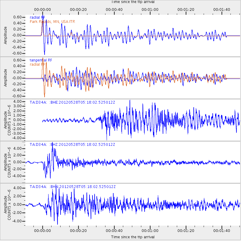
Signal To Noise
| Channel | StoN | STA | LTA |
| TA:D34A: :BHZ:20120528T05:18:02.525012Z | 12.919129 | 1.9347626E-6 | 1.4975952E-7 |
| TA:D34A: :BHN:20120528T05:18:02.525012Z | 4.7890716 | 9.60662E-7 | 2.0059461E-7 |
| TA:D34A: :BHE:20120528T05:18:02.525012Z | 2.9117944 | 6.099753E-7 | 2.0948433E-7 |
| Arrivals |
| Ps | 2.3 SECOND |
| PpPs | 7.6 SECOND |
| PsPs/PpSs | 9.9 SECOND |


