You are here: Home > Network List > TA - USArray Transportable Network (new EarthScope stations) Stations List
> Station A33A Warroad, MN, USA > Earthquake Result Viewer
A33A Warroad, MN, USA - Earthquake Result Viewer

| Earthquake location: |
Santiago Del Estero Prov., Arg. |
| Earthquake latitude/longitude: |
-28.0/-63.1 |
| Earthquake time(UTC): |
2012/05/28 (149) 05:07:23 GMT |
| Earthquake Depth: |
587 km |
| Earthquake Magnitude: |
6.0 MB, 6.7 MW, 6.8 MW |
| Earthquake Catalog/Contributor: |
WHDF/NEIC |
|
| Network: |
TA USArray Transportable Network (new EarthScope stations) |
| Station: |
A33A Warroad, MN, USA |
| Lat/Lon: |
48.94 N/95.39 W |
| Elevation: |
329 m |
|
| Distance: |
81.9 deg |
| Az: |
339.153 deg |
| Baz: |
151.508 deg |
| Ray Param: |
0.04550441 |
| Estimated Moho Depth: |
54.25 km |
| Estimated Crust Vp/Vs: |
1.77 |
| Assumed Crust Vp: |
6.419 km/s |
| Estimated Crust Vs: |
3.616 km/s |
| Estimated Crust Poisson's Ratio: |
0.27 |
|
| Radial Match: |
82.99389 % |
| Radial Bump: |
400 |
| Transverse Match: |
77.63874 % |
| Transverse Bump: |
400 |
| SOD ConfigId: |
455246 |
| Insert Time: |
2012-09-25 00:01:11.670 +0000 |
| GWidth: |
2.5 |
| Max Bumps: |
400 |
| Tol: |
0.001 |
|
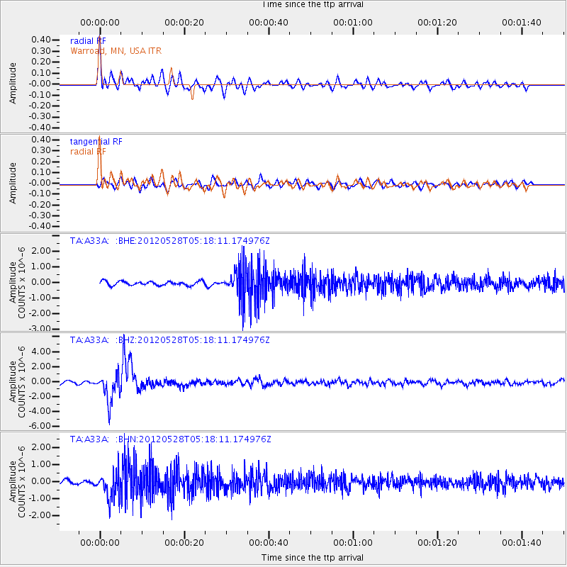
Signal To Noise
| Channel | StoN | STA | LTA |
| TA:A33A: :BHZ:20120528T05:18:11.174976Z | 9.662845 | 1.9173838E-6 | 1.984285E-7 |
| TA:A33A: :BHN:20120528T05:18:11.174976Z | 6.7516365 | 7.773676E-7 | 1.1513765E-7 |
| TA:A33A: :BHE:20120528T05:18:11.174976Z | 7.8350444 | 1.002536E-6 | 1.2795536E-7 |
| Arrivals |
| Ps | 6.7 SECOND |
| PpPs | 23 SECOND |
| PsPs/PpSs | 30 SECOND |


