You are here: Home > Network List > XJ13 - CRAFTI Stations List
> Station PR31 Engaruka Boma > Earthquake Result Viewer
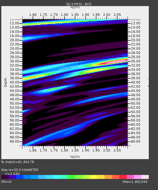
PR31 Engaruka Boma - Earthquake Result Viewer
| Earthquake location: |
Negros, Philippines |
| Earthquake latitude/longitude: |
9.4/122.2 |
| Earthquake time(UTC): |
2014/05/15 (135) 10:16:46 GMT |
| Earthquake Depth: |
53 km |
| Earthquake Magnitude: |
6.2 MWP |
| Earthquake Catalog/Contributor: |
NEIC PDE/NEIC COMCAT |
|
| Network: |
XJ CRAFTI |
| Station: |
PR31 Engaruka Boma |
| Lat/Lon: |
2.92 S/36.05 E |
| Elevation: |
884 m |
|
| Distance: |
86.6 deg |
| Az: |
266.502 deg |
| Baz: |
80.442 deg |
| Ray Param: |
0.043808162 |
| Estimated Moho Depth: |
30.0 km |
| Estimated Crust Vp/Vs: |
2.05 |
| Assumed Crust Vp: |
6.601 km/s |
| Estimated Crust Vs: |
3.228 km/s |
| Estimated Crust Poisson's Ratio: |
0.34 |
|
| Radial Match: |
81.94179 % |
| Radial Bump: |
400 |
| Transverse Match: |
61.519287 % |
| Transverse Bump: |
400 |
| SOD ConfigId: |
3390531 |
| Insert Time: |
2019-04-11 21:39:10.162 +0000 |
| GWidth: |
2.5 |
| Max Bumps: |
400 |
| Tol: |
0.001 |
|

Signal To Noise
| Channel | StoN | STA | LTA |
| XJ:PR31: :BHZ:20140515T10:28:52.860007Z | 8.334453 | 1.0594293E-6 | 1.2711446E-7 |
| XJ:PR31: :BHN:20140515T10:28:52.860007Z | 0.8921013 | 1.4815595E-7 | 1.6607527E-7 |
| XJ:PR31: :BHE:20140515T10:28:52.860007Z | 2.1606278 | 3.2243665E-7 | 1.4923285E-7 |
| Arrivals |
| Ps | 4.9 SECOND |
| PpPs | 14 SECOND |
| PsPs/PpSs | 18 SECOND |


