You are here: Home > Network List > TA - USArray Transportable Network (new EarthScope stations) Stations List
> Station R39A Chumby, Stover, MO, USA > Earthquake Result Viewer
R39A Chumby, Stover, MO, USA - Earthquake Result Viewer
| Earthquake location: |
Santiago Del Estero Prov., Arg. |
| Earthquake latitude/longitude: |
-28.0/-63.1 |
| Earthquake time(UTC): |
2012/05/28 (149) 05:07:23 GMT |
| Earthquake Depth: |
587 km |
| Earthquake Magnitude: |
6.0 MB, 6.7 MW, 6.8 MW |
| Earthquake Catalog/Contributor: |
WHDF/NEIC |
|
| Network: |
TA USArray Transportable Network (new EarthScope stations) |
| Station: |
R39A Chumby, Stover, MO, USA |
| Lat/Lon: |
38.31 N/93.04 W |
| Elevation: |
290 m |
|
| Distance: |
71.7 deg |
| Az: |
335.572 deg |
| Baz: |
152.311 deg |
| Ray Param: |
0.052151043 |
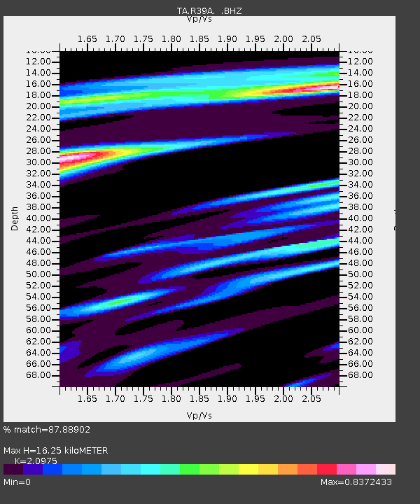
| Estimated Moho Depth: |
16.25 km |
| Estimated Crust Vp/Vs: |
2.10 |
| Assumed Crust Vp: |
6.498 km/s |
| Estimated Crust Vs: |
3.098 km/s |
| Estimated Crust Poisson's Ratio: |
0.35 |
|
| Radial Match: |
87.88902 % |
| Radial Bump: |
390 |
| Transverse Match: |
78.27761 % |
| Transverse Bump: |
398 |
| SOD ConfigId: |
455246 |
| Insert Time: |
2012-09-25 00:04:14.318 +0000 |
| GWidth: |
2.5 |
| Max Bumps: |
400 |
| Tol: |
0.001 |
|

Signal To Noise
| Channel | StoN | STA | LTA |
| TA:R39A: :BHZ:20120528T05:17:16.049976Z | 8.908221 | 1.5582395E-6 | 1.7492152E-7 |
| TA:R39A: :BHN:20120528T05:17:16.049976Z | 5.628142 | 6.1733675E-7 | 1.0968749E-7 |
| TA:R39A: :BHE:20120528T05:17:16.049976Z | 3.396287 | 4.8593546E-7 | 1.4307845E-7 |
| Arrivals |
| Ps | 2.8 SECOND |
| PpPs | 7.5 SECOND |
| PsPs/PpSs | 10 SECOND |


