You are here: Home > Network List > TA - USArray Transportable Network (new EarthScope stations) Stations List
> Station Y47A UCPARC, Winfield, AL, USA > Earthquake Result Viewer
Y47A UCPARC, Winfield, AL, USA - Earthquake Result Viewer
| Earthquake location: |
Santiago Del Estero Prov., Arg. |
| Earthquake latitude/longitude: |
-28.0/-63.1 |
| Earthquake time(UTC): |
2012/05/28 (149) 05:07:23 GMT |
| Earthquake Depth: |
587 km |
| Earthquake Magnitude: |
6.0 MB, 6.7 MW, 6.8 MW |
| Earthquake Catalog/Contributor: |
WHDF/NEIC |
|
| Network: |
TA USArray Transportable Network (new EarthScope stations) |
| Station: |
Y47A UCPARC, Winfield, AL, USA |
| Lat/Lon: |
33.90 N/87.85 W |
| Elevation: |
160 m |
|
| Distance: |
65.9 deg |
| Az: |
337.576 deg |
| Baz: |
156.084 deg |
| Ray Param: |
0.055800617 |
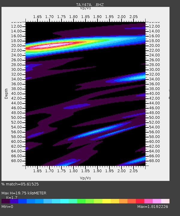
| Estimated Moho Depth: |
19.75 km |
| Estimated Crust Vp/Vs: |
1.70 |
| Assumed Crust Vp: |
6.565 km/s |
| Estimated Crust Vs: |
3.861 km/s |
| Estimated Crust Poisson's Ratio: |
0.24 |
|
| Radial Match: |
85.61525 % |
| Radial Bump: |
400 |
| Transverse Match: |
72.860374 % |
| Transverse Bump: |
400 |
| SOD ConfigId: |
455246 |
| Insert Time: |
2012-09-25 00:09:19.104 +0000 |
| GWidth: |
2.5 |
| Max Bumps: |
400 |
| Tol: |
0.001 |
|

Signal To Noise
| Channel | StoN | STA | LTA |
| TA:Y47A: :BHZ:20120528T05:16:41.400012Z | 7.57121 | 3.1311642E-6 | 4.1356196E-7 |
| TA:Y47A: :BHN:20120528T05:16:41.400012Z | 3.9790123 | 1.0371771E-6 | 2.6066198E-7 |
| TA:Y47A: :BHE:20120528T05:16:41.400012Z | 1.442993 | 4.6347938E-7 | 3.2119306E-7 |
| Arrivals |
| Ps | 2.2 SECOND |
| PpPs | 7.8 SECOND |
| PsPs/PpSs | 10.0 SECOND |


