You are here: Home > Network List > G - GEOSCOPE Stations List
> Station RER Riviere de l'Est, La Reunion (Indian Ocean) > Earthquake Result Viewer
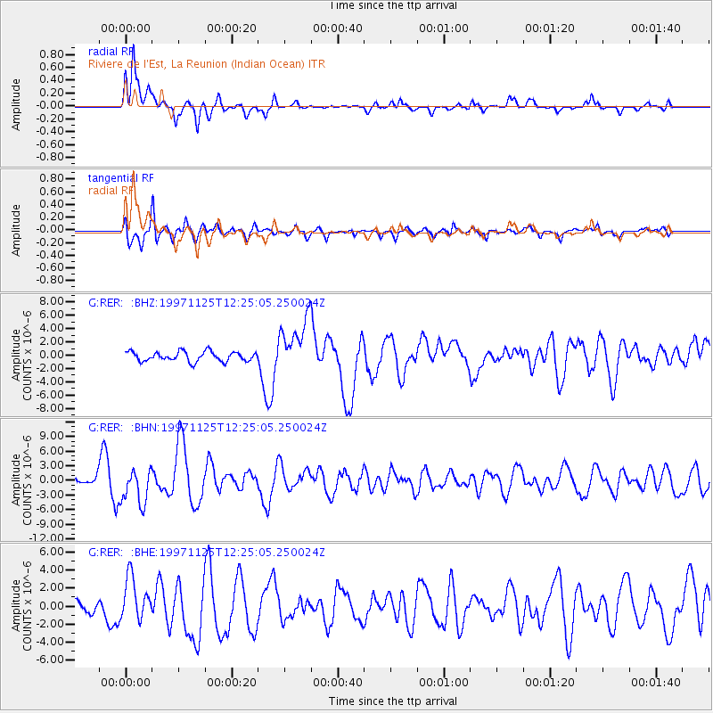
RER Riviere de l'Est, La Reunion (Indian Ocean) - Earthquake Result Viewer
*The percent match for this event was below the threshold and hence no stack was calculated.
| Earthquake location: |
Minahassa Peninsula, Sulawesi |
| Earthquake latitude/longitude: |
1.2/122.5 |
| Earthquake time(UTC): |
1997/11/25 (329) 12:14:33 GMT |
| Earthquake Depth: |
24 km |
| Earthquake Magnitude: |
6.1 MB, 6.8 MS, 7.1 UNKNOWN, 6.7 ME |
| Earthquake Catalog/Contributor: |
WHDF/NEIC |
|
| Network: |
G GEOSCOPE |
| Station: |
RER Riviere de l'Est, La Reunion (Indian Ocean) |
| Lat/Lon: |
21.16 S/55.75 E |
| Elevation: |
834 m |
|
| Distance: |
68.9 deg |
| Az: |
246.856 deg |
| Baz: |
80.033 deg |
| Ray Param: |
$rayparam |
*The percent match for this event was below the threshold and hence was not used in the summary stack. |
|
| Radial Match: |
89.2906 % |
| Radial Bump: |
368 |
| Transverse Match: |
89.757675 % |
| Transverse Bump: |
400 |
| SOD ConfigId: |
4480 |
| Insert Time: |
2010-02-26 23:47:05.022 +0000 |
| GWidth: |
2.5 |
| Max Bumps: |
400 |
| Tol: |
0.001 |
|
Signal To Noise
| Channel | StoN | STA | LTA |
| G:RER: :BHN:19971125T12:25:05.250024Z | 7.011354 | 3.5641824E-6 | 5.083444E-7 |
| G:RER: :BHE:19971125T12:25:05.250024Z | 5.8286977 | 2.4045191E-6 | 4.125311E-7 |
| G:RER: :BHZ:19971125T12:25:05.250024Z | 5.5123734 | 4.0548207E-6 | 7.355852E-7 |
| Arrivals |
| Ps | |
| PpPs | |
| PsPs/PpSs | |


