You are here: Home > Network List > TA - USArray Transportable Network (new EarthScope stations) Stations List
> Station R42A Luebbering, MO, USA > Earthquake Result Viewer
R42A Luebbering, MO, USA - Earthquake Result Viewer
| Earthquake location: |
Santiago Del Estero Prov., Arg. |
| Earthquake latitude/longitude: |
-28.0/-63.1 |
| Earthquake time(UTC): |
2012/05/28 (149) 05:07:23 GMT |
| Earthquake Depth: |
587 km |
| Earthquake Magnitude: |
6.0 MB, 6.7 MW, 6.8 MW |
| Earthquake Catalog/Contributor: |
WHDF/NEIC |
|
| Network: |
TA USArray Transportable Network (new EarthScope stations) |
| Station: |
R42A Luebbering, MO, USA |
| Lat/Lon: |
38.28 N/90.79 W |
| Elevation: |
218 m |
|
| Distance: |
70.9 deg |
| Az: |
337.221 deg |
| Baz: |
154.225 deg |
| Ray Param: |
0.05267797 |
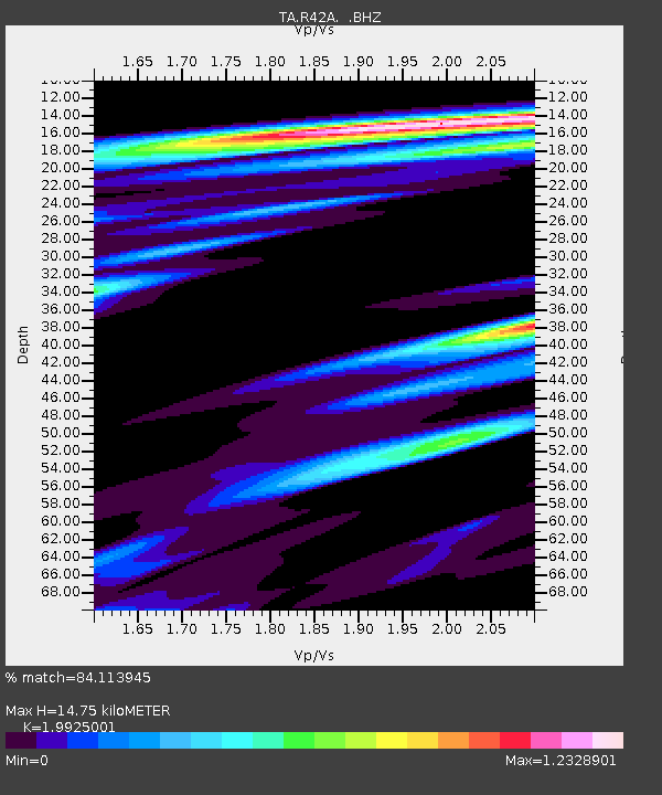
| Estimated Moho Depth: |
14.75 km |
| Estimated Crust Vp/Vs: |
1.99 |
| Assumed Crust Vp: |
6.498 km/s |
| Estimated Crust Vs: |
3.261 km/s |
| Estimated Crust Poisson's Ratio: |
0.33 |
|
| Radial Match: |
84.113945 % |
| Radial Bump: |
400 |
| Transverse Match: |
52.971367 % |
| Transverse Bump: |
400 |
| SOD ConfigId: |
455246 |
| Insert Time: |
2012-09-25 00:12:56.949 +0000 |
| GWidth: |
2.5 |
| Max Bumps: |
400 |
| Tol: |
0.001 |
|
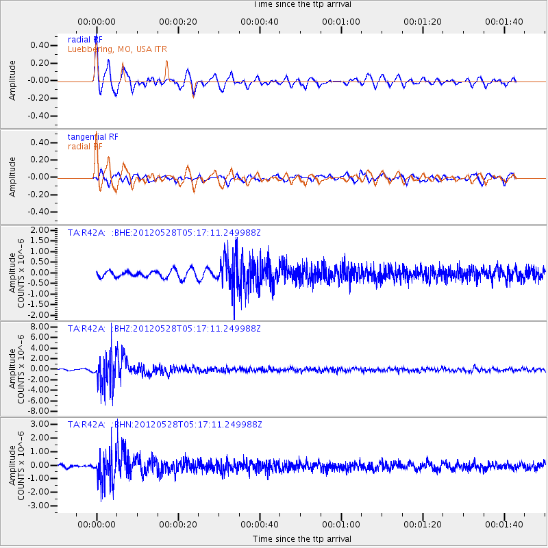
Signal To Noise
| Channel | StoN | STA | LTA |
| TA:R42A: :BHZ:20120528T05:17:11.249988Z | 18.341724 | 3.0232943E-6 | 1.6483153E-7 |
| TA:R42A: :BHN:20120528T05:17:11.249988Z | 8.582161 | 1.0531238E-6 | 1.2271079E-7 |
| TA:R42A: :BHE:20120528T05:17:11.249988Z | 4.197819 | 7.174521E-7 | 1.7091067E-7 |
| Arrivals |
| Ps | 2.3 SECOND |
| PpPs | 6.6 SECOND |
| PsPs/PpSs | 8.9 SECOND |


