You are here: Home > Network List > TA - USArray Transportable Network (new EarthScope stations) Stations List
> Station I41A Arkdale, WI, USA > Earthquake Result Viewer
I41A Arkdale, WI, USA - Earthquake Result Viewer
| Earthquake location: |
Santiago Del Estero Prov., Arg. |
| Earthquake latitude/longitude: |
-28.0/-63.1 |
| Earthquake time(UTC): |
2012/05/28 (149) 05:07:23 GMT |
| Earthquake Depth: |
587 km |
| Earthquake Magnitude: |
6.0 MB, 6.7 MW, 6.8 MW |
| Earthquake Catalog/Contributor: |
WHDF/NEIC |
|
| Network: |
TA USArray Transportable Network (new EarthScope stations) |
| Station: |
I41A Arkdale, WI, USA |
| Lat/Lon: |
44.06 N/89.87 W |
| Elevation: |
289 m |
|
| Distance: |
75.8 deg |
| Az: |
340.429 deg |
| Baz: |
155.752 deg |
| Ray Param: |
0.049512513 |
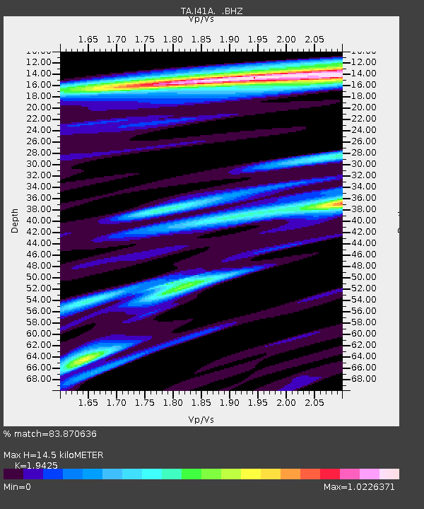
| Estimated Moho Depth: |
14.5 km |
| Estimated Crust Vp/Vs: |
1.94 |
| Assumed Crust Vp: |
6.41 km/s |
| Estimated Crust Vs: |
3.3 km/s |
| Estimated Crust Poisson's Ratio: |
0.32 |
|
| Radial Match: |
83.870636 % |
| Radial Bump: |
400 |
| Transverse Match: |
60.64104 % |
| Transverse Bump: |
400 |
| SOD ConfigId: |
455246 |
| Insert Time: |
2012-09-25 00:13:50.790 +0000 |
| GWidth: |
2.5 |
| Max Bumps: |
400 |
| Tol: |
0.001 |
|

Signal To Noise
| Channel | StoN | STA | LTA |
| TA:I41A: :BHZ:20120528T05:17:39.225024Z | 9.402616 | 1.6356441E-6 | 1.739563E-7 |
| TA:I41A: :BHN:20120528T05:17:39.225024Z | 5.427201 | 8.783162E-7 | 1.6183596E-7 |
| TA:I41A: :BHE:20120528T05:17:39.225024Z | 4.382672 | 5.3877056E-7 | 1.2293198E-7 |
| Arrivals |
| Ps | 2.2 SECOND |
| PpPs | 6.5 SECOND |
| PsPs/PpSs | 8.7 SECOND |


