You are here: Home > Network List > TA - USArray Transportable Network (new EarthScope stations) Stations List
> Station F37A Hinrichs Farm, Grantsburg, WI, USA > Earthquake Result Viewer
F37A Hinrichs Farm, Grantsburg, WI, USA - Earthquake Result Viewer
| Earthquake location: |
Santiago Del Estero Prov., Arg. |
| Earthquake latitude/longitude: |
-28.0/-63.1 |
| Earthquake time(UTC): |
2012/05/28 (149) 05:07:23 GMT |
| Earthquake Depth: |
587 km |
| Earthquake Magnitude: |
6.0 MB, 6.7 MW, 6.8 MW |
| Earthquake Catalog/Contributor: |
WHDF/NEIC |
|
| Network: |
TA USArray Transportable Network (new EarthScope stations) |
| Station: |
F37A Hinrichs Farm, Grantsburg, WI, USA |
| Lat/Lon: |
45.72 N/92.63 W |
| Elevation: |
296 m |
|
| Distance: |
78.2 deg |
| Az: |
339.342 deg |
| Baz: |
153.568 deg |
| Ray Param: |
0.0479893 |
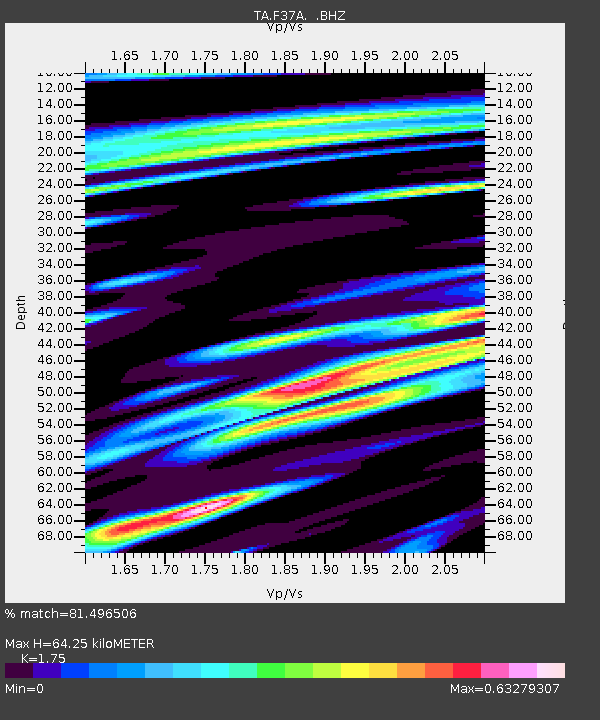
| Estimated Moho Depth: |
64.25 km |
| Estimated Crust Vp/Vs: |
1.75 |
| Assumed Crust Vp: |
6.571 km/s |
| Estimated Crust Vs: |
3.755 km/s |
| Estimated Crust Poisson's Ratio: |
0.26 |
|
| Radial Match: |
81.496506 % |
| Radial Bump: |
400 |
| Transverse Match: |
76.82774 % |
| Transverse Bump: |
400 |
| SOD ConfigId: |
455246 |
| Insert Time: |
2012-09-25 00:15:13.919 +0000 |
| GWidth: |
2.5 |
| Max Bumps: |
400 |
| Tol: |
0.001 |
|
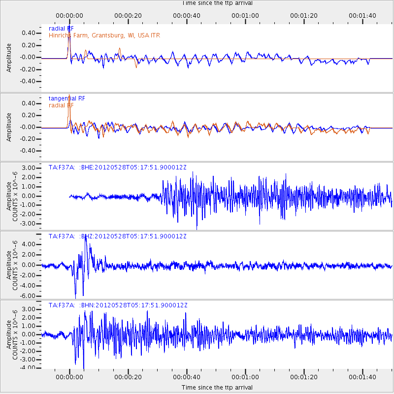
Signal To Noise
| Channel | StoN | STA | LTA |
| TA:F37A: :BHZ:20120528T05:17:51.900012Z | 12.928477 | 2.0988464E-6 | 1.623429E-7 |
| TA:F37A: :BHN:20120528T05:17:51.900012Z | 9.669446 | 1.3177919E-6 | 1.3628411E-7 |
| TA:F37A: :BHE:20120528T05:17:51.900012Z | 5.4327245 | 7.3850333E-7 | 1.3593609E-7 |
| Arrivals |
| Ps | 7.6 SECOND |
| PpPs | 26 SECOND |
| PsPs/PpSs | 34 SECOND |


