You are here: Home > Network List > TA - USArray Transportable Network (new EarthScope stations) Stations List
> Station D41A Chassel, MI, USA > Earthquake Result Viewer
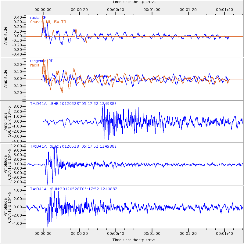
D41A Chassel, MI, USA - Earthquake Result Viewer
*The percent match for this event was below the threshold and hence no stack was calculated.
| Earthquake location: |
Santiago Del Estero Prov., Arg. |
| Earthquake latitude/longitude: |
-28.0/-63.1 |
| Earthquake time(UTC): |
2012/05/28 (149) 05:07:23 GMT |
| Earthquake Depth: |
587 km |
| Earthquake Magnitude: |
6.0 MB, 6.7 MW, 6.8 MW |
| Earthquake Catalog/Contributor: |
WHDF/NEIC |
|
| Network: |
TA USArray Transportable Network (new EarthScope stations) |
| Station: |
D41A Chassel, MI, USA |
| Lat/Lon: |
47.06 N/88.57 W |
| Elevation: |
271 m |
|
| Distance: |
78.2 deg |
| Az: |
342.521 deg |
| Baz: |
157.15 deg |
| Ray Param: |
$rayparam |
*The percent match for this event was below the threshold and hence was not used in the summary stack. |
|
| Radial Match: |
73.49592 % |
| Radial Bump: |
400 |
| Transverse Match: |
67.52754 % |
| Transverse Bump: |
400 |
| SOD ConfigId: |
455246 |
| Insert Time: |
2012-09-25 00:15:54.579 +0000 |
| GWidth: |
2.5 |
| Max Bumps: |
400 |
| Tol: |
0.001 |
|
Signal To Noise
| Channel | StoN | STA | LTA |
| TA:D41A: :BHZ:20120528T05:17:52.124988Z | 15.127523 | 4.4510816E-6 | 2.9423728E-7 |
| TA:D41A: :BHN:20120528T05:17:52.124988Z | 6.36403 | 1.7787312E-6 | 2.794976E-7 |
| TA:D41A: :BHE:20120528T05:17:52.124988Z | 3.8372443 | 1.2686482E-6 | 3.306144E-7 |
| Arrivals |
| Ps | |
| PpPs | |
| PsPs/PpSs | |


