You are here: Home > Network List > TA - USArray Transportable Network (new EarthScope stations) Stations List
> Station H42A Shiocton, WI, USA > Earthquake Result Viewer
H42A Shiocton, WI, USA - Earthquake Result Viewer
| Earthquake location: |
Santiago Del Estero Prov., Arg. |
| Earthquake latitude/longitude: |
-28.0/-63.1 |
| Earthquake time(UTC): |
2012/05/28 (149) 05:07:23 GMT |
| Earthquake Depth: |
587 km |
| Earthquake Magnitude: |
6.0 MB, 6.7 MW, 6.8 MW |
| Earthquake Catalog/Contributor: |
WHDF/NEIC |
|
| Network: |
TA USArray Transportable Network (new EarthScope stations) |
| Station: |
H42A Shiocton, WI, USA |
| Lat/Lon: |
44.51 N/88.53 W |
| Elevation: |
244 m |
|
| Distance: |
75.9 deg |
| Az: |
341.523 deg |
| Baz: |
156.951 deg |
| Ray Param: |
0.049495526 |
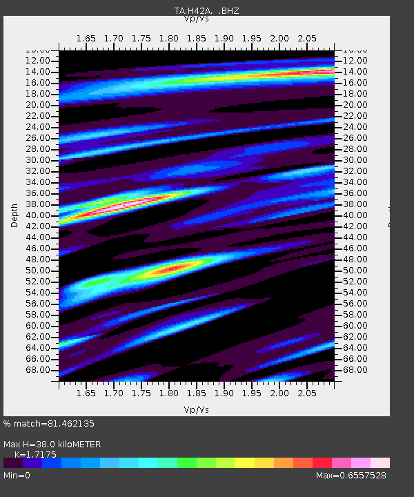
| Estimated Moho Depth: |
38.0 km |
| Estimated Crust Vp/Vs: |
1.72 |
| Assumed Crust Vp: |
6.41 km/s |
| Estimated Crust Vs: |
3.732 km/s |
| Estimated Crust Poisson's Ratio: |
0.24 |
|
| Radial Match: |
81.462135 % |
| Radial Bump: |
400 |
| Transverse Match: |
64.41668 % |
| Transverse Bump: |
400 |
| SOD ConfigId: |
455246 |
| Insert Time: |
2012-09-25 00:17:01.199 +0000 |
| GWidth: |
2.5 |
| Max Bumps: |
400 |
| Tol: |
0.001 |
|
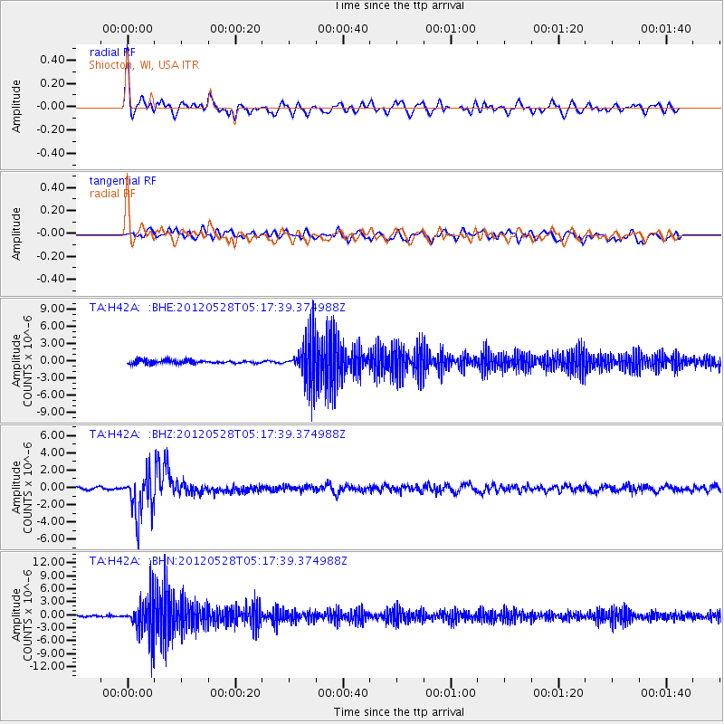
Signal To Noise
| Channel | StoN | STA | LTA |
| TA:H42A: :BHZ:20120528T05:17:39.374988Z | 9.803249 | 2.4070243E-6 | 2.4553333E-7 |
| TA:H42A: :BHN:20120528T05:17:39.374988Z | 11.44609 | 4.14835E-6 | 3.6242508E-7 |
| TA:H42A: :BHE:20120528T05:17:39.374988Z | 12.890466 | 3.634679E-6 | 2.8196646E-7 |
| Arrivals |
| Ps | 4.4 SECOND |
| PpPs | 16 SECOND |
| PsPs/PpSs | 20 SECOND |


