You are here: Home > Network List > TA - USArray Transportable Network (new EarthScope stations) Stations List
> Station J42A Columbus, WI, USA > Earthquake Result Viewer
J42A Columbus, WI, USA - Earthquake Result Viewer

| Earthquake location: |
Santiago Del Estero Prov., Arg. |
| Earthquake latitude/longitude: |
-28.0/-63.1 |
| Earthquake time(UTC): |
2012/05/28 (149) 05:07:23 GMT |
| Earthquake Depth: |
587 km |
| Earthquake Magnitude: |
6.0 MB, 6.7 MW, 6.8 MW |
| Earthquake Catalog/Contributor: |
WHDF/NEIC |
|
| Network: |
TA USArray Transportable Network (new EarthScope stations) |
| Station: |
J42A Columbus, WI, USA |
| Lat/Lon: |
43.32 N/89.12 W |
| Elevation: |
313 m |
|
| Distance: |
74.9 deg |
| Az: |
340.629 deg |
| Baz: |
156.316 deg |
| Ray Param: |
0.050094504 |
| Estimated Moho Depth: |
18.75 km |
| Estimated Crust Vp/Vs: |
1.75 |
| Assumed Crust Vp: |
6.571 km/s |
| Estimated Crust Vs: |
3.755 km/s |
| Estimated Crust Poisson's Ratio: |
0.26 |
|
| Radial Match: |
85.74047 % |
| Radial Bump: |
400 |
| Transverse Match: |
70.574554 % |
| Transverse Bump: |
400 |
| SOD ConfigId: |
455246 |
| Insert Time: |
2012-09-25 00:17:42.197 +0000 |
| GWidth: |
2.5 |
| Max Bumps: |
400 |
| Tol: |
0.001 |
|
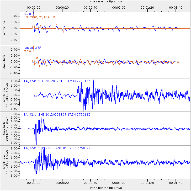
Signal To Noise
| Channel | StoN | STA | LTA |
| TA:J42A: :BHZ:20120528T05:17:34.275012Z | 15.123215 | 2.8412844E-6 | 1.8787568E-7 |
| TA:J42A: :BHN:20120528T05:17:34.275012Z | 8.007666 | 1.2395969E-6 | 1.548013E-7 |
| TA:J42A: :BHE:20120528T05:17:34.275012Z | 3.4791365 | 5.5420776E-7 | 1.5929463E-7 |
| Arrivals |
| Ps | 2.2 SECOND |
| PpPs | 7.6 SECOND |
| PsPs/PpSs | 9.8 SECOND |


