You are here: Home > Network List > TA - USArray Transportable Network (new EarthScope stations) Stations List
> Station Z49A Columbiana, AL, USA > Earthquake Result Viewer
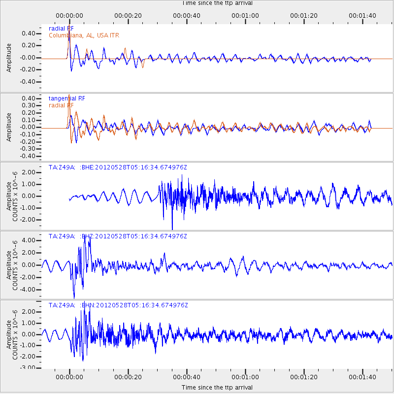
Z49A Columbiana, AL, USA - Earthquake Result Viewer
*The percent match for this event was below the threshold and hence no stack was calculated.
| Earthquake location: |
Santiago Del Estero Prov., Arg. |
| Earthquake latitude/longitude: |
-28.0/-63.1 |
| Earthquake time(UTC): |
2012/05/28 (149) 05:07:23 GMT |
| Earthquake Depth: |
587 km |
| Earthquake Magnitude: |
6.0 MB, 6.7 MW, 6.8 MW |
| Earthquake Catalog/Contributor: |
WHDF/NEIC |
|
| Network: |
TA USArray Transportable Network (new EarthScope stations) |
| Station: |
Z49A Columbiana, AL, USA |
| Lat/Lon: |
33.19 N/86.53 W |
| Elevation: |
134 m |
|
| Distance: |
64.8 deg |
| Az: |
338.379 deg |
| Baz: |
157.144 deg |
| Ray Param: |
$rayparam |
*The percent match for this event was below the threshold and hence was not used in the summary stack. |
|
| Radial Match: |
74.33983 % |
| Radial Bump: |
400 |
| Transverse Match: |
67.932205 % |
| Transverse Bump: |
400 |
| SOD ConfigId: |
455246 |
| Insert Time: |
2012-09-25 00:20:23.018 +0000 |
| GWidth: |
2.5 |
| Max Bumps: |
400 |
| Tol: |
0.001 |
|
Signal To Noise
| Channel | StoN | STA | LTA |
| TA:Z49A: :BHZ:20120528T05:16:34.674976Z | 4.6331644 | 2.0863156E-6 | 4.5030038E-7 |
| TA:Z49A: :BHN:20120528T05:16:34.674976Z | 3.9808967 | 1.0520481E-6 | 2.6427415E-7 |
| TA:Z49A: :BHE:20120528T05:16:34.674976Z | 2.2754438 | 6.696824E-7 | 2.9430848E-7 |
| Arrivals |
| Ps | |
| PpPs | |
| PsPs/PpSs | |


