You are here: Home > Network List > G - GEOSCOPE Stations List
> Station SCZ Chualar Canyon, Santa Cruz, California, U.S.A. > Earthquake Result Viewer
SCZ Chualar Canyon, Santa Cruz, California, U.S.A. - Earthquake Result Viewer

| Earthquake location: |
South Of Panama |
| Earthquake latitude/longitude: |
7.5/-82.3 |
| Earthquake time(UTC): |
1992/05/18 (139) 23:19:20 GMT |
| Earthquake Depth: |
11 km |
| Earthquake Magnitude: |
6.0 MB, 6.0 MS |
| Earthquake Catalog/Contributor: |
WHDF/NEIC |
|
| Network: |
G GEOSCOPE |
| Station: |
SCZ Chualar Canyon, Santa Cruz, California, U.S.A. |
| Lat/Lon: |
36.60 N/121.40 W |
| Elevation: |
261 m |
|
| Distance: |
45.8 deg |
| Az: |
315.001 deg |
| Baz: |
119.405 deg |
| Ray Param: |
0.07101478 |
| Estimated Moho Depth: |
25.25 km |
| Estimated Crust Vp/Vs: |
1.68 |
| Assumed Crust Vp: |
6.391 km/s |
| Estimated Crust Vs: |
3.798 km/s |
| Estimated Crust Poisson's Ratio: |
0.23 |
|
| Radial Match: |
91.68333 % |
| Radial Bump: |
400 |
| Transverse Match: |
82.8901 % |
| Transverse Bump: |
400 |
| SOD ConfigId: |
16938 |
| Insert Time: |
2010-02-26 23:47:26.820 +0000 |
| GWidth: |
2.5 |
| Max Bumps: |
400 |
| Tol: |
0.001 |
|
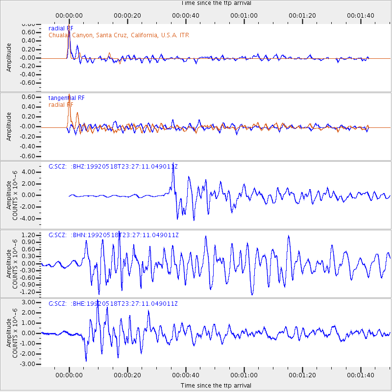
Signal To Noise
| Channel | StoN | STA | LTA |
| G:SCZ: :BHN:19920518T23:27:11.049011Z | 1.9608214 | 1.16537784E-7 | 5.9433148E-8 |
| G:SCZ: :BHE:19920518T23:27:11.049011Z | 2.31658 | 1.8926065E-7 | 8.1698296E-8 |
| G:SCZ: :BHZ:19920518T23:27:11.049011Z | 3.9020057 | 4.7938613E-7 | 1.2285633E-7 |
| Arrivals |
| Ps | 2.9 SECOND |
| PpPs | 9.9 SECOND |
| PsPs/PpSs | 13 SECOND |


