You are here: Home > Network List > UW - Pacific Northwest Regional Seismic Network Stations List
> Station HOOD Mt Hood Meadows, OR CREST BB SMO > Earthquake Result Viewer
HOOD Mt Hood Meadows, OR CREST BB SMO - Earthquake Result Viewer
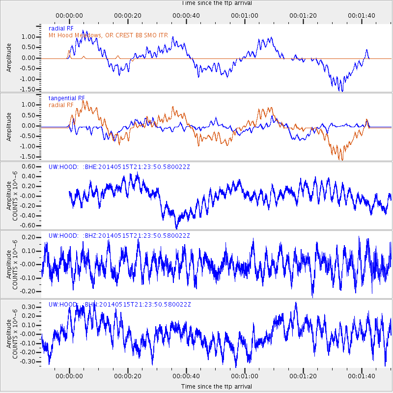
*The percent match for this event was below the threshold and hence no stack was calculated.
| Earthquake location: |
Philippine Islands Region |
| Earthquake latitude/longitude: |
19.5/121.3 |
| Earthquake time(UTC): |
2014/05/15 (135) 21:11:04 GMT |
| Earthquake Depth: |
10 km |
| Earthquake Magnitude: |
4.6 mb |
| Earthquake Catalog/Contributor: |
ISC/ISC |
|
| Network: |
UW Pacific Northwest Regional Seismic Network |
| Station: |
HOOD Mt Hood Meadows, OR CREST BB SMO |
| Lat/Lon: |
45.32 N/121.65 W |
| Elevation: |
1520 m |
|
| Distance: |
93.8 deg |
| Az: |
39.041 deg |
| Baz: |
302.642 deg |
| Ray Param: |
$rayparam |
*The percent match for this event was below the threshold and hence was not used in the summary stack. |
|
| Radial Match: |
45.489964 % |
| Radial Bump: |
400 |
| Transverse Match: |
47.671997 % |
| Transverse Bump: |
400 |
| SOD ConfigId: |
3390531 |
| Insert Time: |
2019-04-11 21:43:49.990 +0000 |
| GWidth: |
2.5 |
| Max Bumps: |
400 |
| Tol: |
0.001 |
|
Signal To Noise
| Channel | StoN | STA | LTA |
| UW:HOOD: :BHZ:20140515T21:23:50.580022Z | 1.0026853 | 7.636797E-8 | 7.6163445E-8 |
| UW:HOOD: :BHN:20140515T21:23:50.580022Z | 1.1910559 | 2.2975087E-7 | 1.9289679E-7 |
| UW:HOOD: :BHE:20140515T21:23:50.580022Z | 2.2361708 | 3.3938295E-7 | 1.517697E-7 |
| Arrivals |
| Ps | |
| PpPs | |
| PsPs/PpSs | |


