You are here: Home > Network List > UW - Pacific Northwest Regional Seismic Network Stations List
> Station PASS Maple Falls, WA, USA > Earthquake Result Viewer
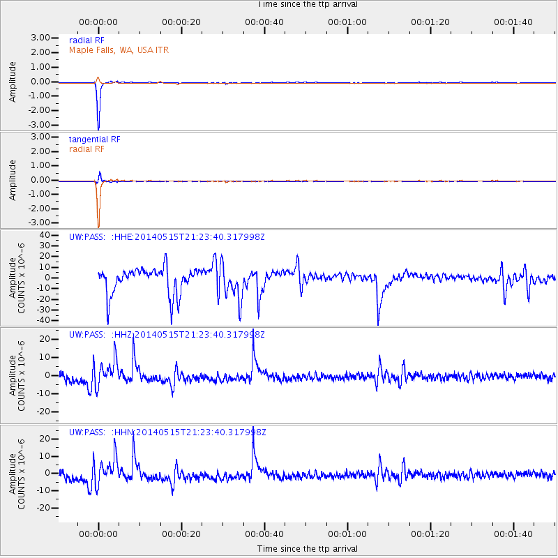
PASS Maple Falls, WA, USA - Earthquake Result Viewer
*The percent match for this event was below the threshold and hence no stack was calculated.
| Earthquake location: |
Philippine Islands Region |
| Earthquake latitude/longitude: |
19.5/121.3 |
| Earthquake time(UTC): |
2014/05/15 (135) 21:11:04 GMT |
| Earthquake Depth: |
10 km |
| Earthquake Magnitude: |
4.6 mb |
| Earthquake Catalog/Contributor: |
ISC/ISC |
|
| Network: |
UW Pacific Northwest Regional Seismic Network |
| Station: |
PASS Maple Falls, WA, USA |
| Lat/Lon: |
49.00 N/122.09 W |
| Elevation: |
174 m |
|
| Distance: |
91.6 deg |
| Az: |
36.096 deg |
| Baz: |
302.466 deg |
| Ray Param: |
$rayparam |
*The percent match for this event was below the threshold and hence was not used in the summary stack. |
|
| Radial Match: |
99.23323 % |
| Radial Bump: |
96 |
| Transverse Match: |
92.14263 % |
| Transverse Bump: |
400 |
| SOD ConfigId: |
3390531 |
| Insert Time: |
2019-04-11 21:43:52.045 +0000 |
| GWidth: |
2.5 |
| Max Bumps: |
400 |
| Tol: |
0.001 |
|
Signal To Noise
| Channel | StoN | STA | LTA |
| UW:PASS: :HHZ:20140515T21:23:40.317998Z | 1.2719963 | 7.3154747E-6 | 5.7511766E-6 |
| UW:PASS: :HHN:20140515T21:23:40.317998Z | 1.2824241 | 7.871398E-6 | 6.137906E-6 |
| UW:PASS: :HHE:20140515T21:23:40.317998Z | 1.3600051 | 1.6601807E-5 | 1.2207166E-5 |
| Arrivals |
| Ps | |
| PpPs | |
| PsPs/PpSs | |


