You are here: Home > Network List > TA - USArray Transportable Network (new EarthScope stations) Stations List
> Station V53A Saluda, NC, USA > Earthquake Result Viewer
V53A Saluda, NC, USA - Earthquake Result Viewer
| Earthquake location: |
Santiago Del Estero Prov., Arg. |
| Earthquake latitude/longitude: |
-28.0/-63.1 |
| Earthquake time(UTC): |
2012/05/28 (149) 05:07:23 GMT |
| Earthquake Depth: |
587 km |
| Earthquake Magnitude: |
6.0 MB, 6.7 MW, 6.8 MW |
| Earthquake Catalog/Contributor: |
WHDF/NEIC |
|
| Network: |
TA USArray Transportable Network (new EarthScope stations) |
| Station: |
V53A Saluda, NC, USA |
| Lat/Lon: |
35.67 N/82.81 W |
| Elevation: |
681 m |
|
| Distance: |
66.0 deg |
| Az: |
342.505 deg |
| Baz: |
160.954 deg |
| Ray Param: |
0.055724483 |
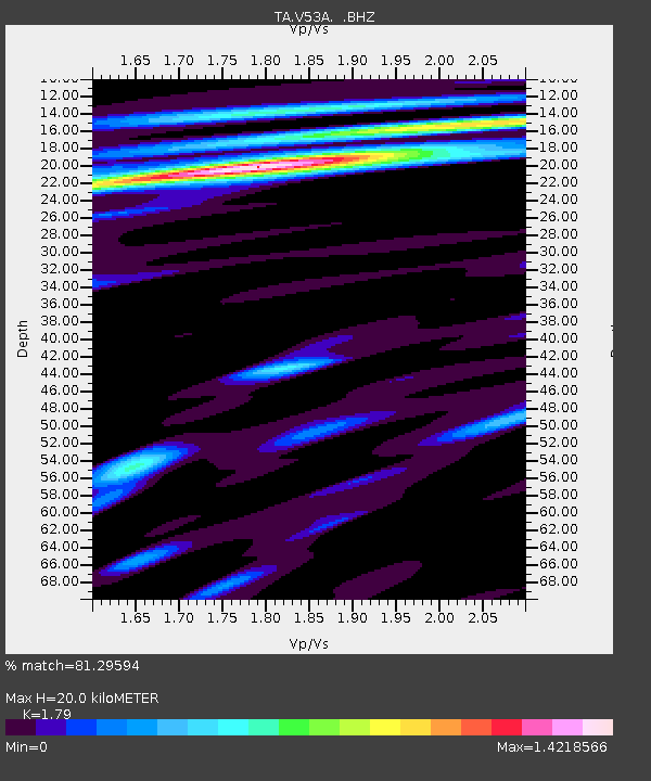
| Estimated Moho Depth: |
20.0 km |
| Estimated Crust Vp/Vs: |
1.79 |
| Assumed Crust Vp: |
6.35 km/s |
| Estimated Crust Vs: |
3.547 km/s |
| Estimated Crust Poisson's Ratio: |
0.27 |
|
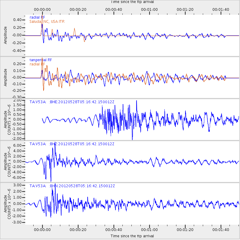
| Radial Match: |
81.29594 % |
| Radial Bump: |
400 |
| Transverse Match: |
78.401085 % |
| Transverse Bump: |
400 |
| SOD ConfigId: |
455246 |
| Insert Time: |
2012-09-25 00:25:20.177 +0000 |
| GWidth: |
2.5 |
| Max Bumps: |
400 |
| Tol: |
0.001 |
|
Signal To Noise
| Channel | StoN | STA | LTA |
| TA:V53A: :BHZ:20120528T05:16:42.150012Z | 10.476577 | 2.8799932E-6 | 2.748983E-7 |
| TA:V53A: :BHN:20120528T05:16:42.150012Z | 4.274235 | 9.279186E-7 | 2.1709586E-7 |
| TA:V53A: :BHE:20120528T05:16:42.150012Z | 3.1460278 | 4.4736467E-7 | 1.4219985E-7 |
| Arrivals |
| Ps | 2.6 SECOND |
| PpPs | 8.5 SECOND |
| PsPs/PpSs | 11 SECOND |


