You are here: Home > Network List > G - GEOSCOPE Stations List
> Station SCZ Chualar Canyon, Santa Cruz, California, U.S.A. > Earthquake Result Viewer
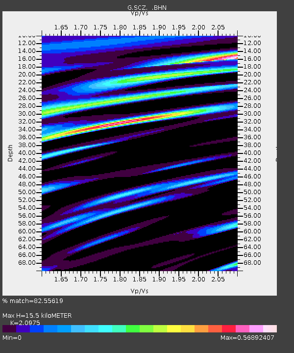
SCZ Chualar Canyon, Santa Cruz, California, U.S.A. - Earthquake Result Viewer
| Earthquake location: |
Near Coast Of Chiapas, Mexico |
| Earthquake latitude/longitude: |
14.5/-92.9 |
| Earthquake time(UTC): |
1992/05/30 (151) 16:30:02 GMT |
| Earthquake Depth: |
57 km |
| Earthquake Magnitude: |
5.6 MB, 6.4 UNKNOWN |
| Earthquake Catalog/Contributor: |
WHDF/NEIC |
|
| Network: |
G GEOSCOPE |
| Station: |
SCZ Chualar Canyon, Santa Cruz, California, U.S.A. |
| Lat/Lon: |
36.60 N/121.40 W |
| Elevation: |
261 m |
|
| Distance: |
33.6 deg |
| Az: |
316.078 deg |
| Baz: |
123.403 deg |
| Ray Param: |
0.07799188 |
| Estimated Moho Depth: |
15.5 km |
| Estimated Crust Vp/Vs: |
2.10 |
| Assumed Crust Vp: |
6.391 km/s |
| Estimated Crust Vs: |
3.047 km/s |
| Estimated Crust Poisson's Ratio: |
0.35 |
|
| Radial Match: |
82.55619 % |
| Radial Bump: |
400 |
| Transverse Match: |
73.711105 % |
| Transverse Bump: |
400 |
| SOD ConfigId: |
16938 |
| Insert Time: |
2010-02-26 23:47:39.908 +0000 |
| GWidth: |
2.5 |
| Max Bumps: |
400 |
| Tol: |
0.001 |
|

Signal To Noise
| Channel | StoN | STA | LTA |
| G:SCZ: :BHN:19920530T16:36:07.200012Z | 1.2321699 | 3.3279258E-7 | 2.7008662E-7 |
| G:SCZ: :BHE:19920530T16:36:07.200012Z | 2.963569 | 5.7031855E-7 | 1.9244314E-7 |
| G:SCZ: :BHZ:19920530T16:36:07.200012Z | 4.243169 | 1.0379816E-6 | 2.4462415E-7 |
| Arrivals |
| Ps | 2.8 SECOND |
| PpPs | 7.0 SECOND |
| PsPs/PpSs | 9.9 SECOND |


