You are here: Home > Network List > UW - Pacific Northwest Regional Seismic Network Stations List
> Station MRBL Marblemount, WA, USA > Earthquake Result Viewer
MRBL Marblemount, WA, USA - Earthquake Result Viewer
*The percent match for this event was below the threshold and hence no stack was calculated.
| Earthquake location: |
Santiago Del Estero Prov., Arg. |
| Earthquake latitude/longitude: |
-28.0/-63.1 |
| Earthquake time(UTC): |
2012/05/28 (149) 05:07:23 GMT |
| Earthquake Depth: |
587 km |
| Earthquake Magnitude: |
6.0 MB, 6.7 MW, 6.8 MW |
| Earthquake Catalog/Contributor: |
WHDF/NEIC |
|
| Network: |
UW Pacific Northwest Regional Seismic Network |
| Station: |
MRBL Marblemount, WA, USA |
| Lat/Lon: |
48.52 N/121.48 W |
| Elevation: |
75 m |
|
| Distance: |
92.4 deg |
| Az: |
325.478 deg |
| Baz: |
131.114 deg |
| Ray Param: |
$rayparam |
*The percent match for this event was below the threshold and hence was not used in the summary stack. |
|
| Radial Match: |
60.03818 % |
| Radial Bump: |
400 |
| Transverse Match: |
48.005634 % |
| Transverse Bump: |
400 |
| SOD ConfigId: |
455246 |
| Insert Time: |
2012-09-25 00:27:50.591 +0000 |
| GWidth: |
2.5 |
| Max Bumps: |
400 |
| Tol: |
0.001 |
|
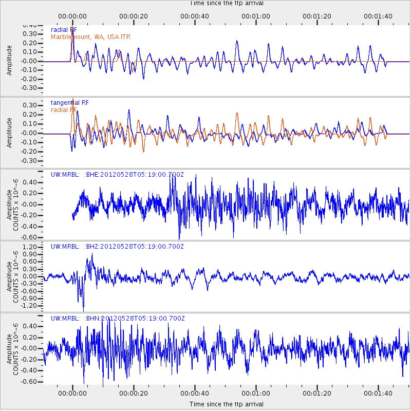
Signal To Noise
| Channel | StoN | STA | LTA |
| UW:MRBL: :BHZ:20120528T05:19:00.700Z | 6.6100636 | 4.733546E-7 | 7.16112E-8 |
| UW:MRBL: :BHN:20120528T05:19:00.700Z | 1.6098068 | 1.9285443E-7 | 1.1979974E-7 |
| UW:MRBL: :BHE:20120528T05:19:00.700Z | 1.8393307 | 2.1326649E-7 | 1.1594788E-7 |
| Arrivals |
| Ps | |
| PpPs | |
| PsPs/PpSs | |


