You are here: Home > Network List > G - GEOSCOPE Stations List
> Station SCZ Chualar Canyon, Santa Cruz, California, U.S.A. > Earthquake Result Viewer
SCZ Chualar Canyon, Santa Cruz, California, U.S.A. - Earthquake Result Viewer

| Earthquake location: |
Off East Coast Of Honshu, Japan |
| Earthquake latitude/longitude: |
39.4/143.4 |
| Earthquake time(UTC): |
1992/07/18 (200) 08:36:59 GMT |
| Earthquake Depth: |
33 km |
| Earthquake Magnitude: |
6.1 MB, 6.9 MS |
| Earthquake Catalog/Contributor: |
WHDF/NEIC |
|
| Network: |
G GEOSCOPE |
| Station: |
SCZ Chualar Canyon, Santa Cruz, California, U.S.A. |
| Lat/Lon: |
36.60 N/121.40 W |
| Elevation: |
261 m |
|
| Distance: |
71.4 deg |
| Az: |
57.709 deg |
| Baz: |
305.476 deg |
| Ray Param: |
0.054272823 |
| Estimated Moho Depth: |
19.0 km |
| Estimated Crust Vp/Vs: |
1.99 |
| Assumed Crust Vp: |
6.391 km/s |
| Estimated Crust Vs: |
3.211 km/s |
| Estimated Crust Poisson's Ratio: |
0.33 |
|
| Radial Match: |
96.50316 % |
| Radial Bump: |
313 |
| Transverse Match: |
81.24596 % |
| Transverse Bump: |
400 |
| SOD ConfigId: |
16938 |
| Insert Time: |
2010-02-26 23:47:45.061 +0000 |
| GWidth: |
2.5 |
| Max Bumps: |
400 |
| Tol: |
0.001 |
|
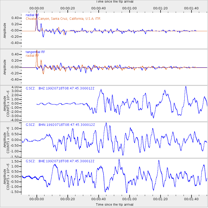
Signal To Noise
| Channel | StoN | STA | LTA |
| G:SCZ: :BHN:19920718T08:47:45.300012Z | 0.6051291 | 8.283965E-8 | 1.3689582E-7 |
| G:SCZ: :BHE:19920718T08:47:45.300012Z | 0.95359915 | 1.5453386E-7 | 1.6205328E-7 |
| G:SCZ: :BHZ:19920718T08:47:45.300012Z | 3.7048829 | 5.322128E-7 | 1.4365173E-7 |
| Arrivals |
| Ps | 3.0 SECOND |
| PpPs | 8.6 SECOND |
| PsPs/PpSs | 12 SECOND |


