You are here: Home > Network List > UW - Pacific Northwest Regional Seismic Network Stations List
> Station LEBA Lebam, WA, USA > Earthquake Result Viewer
LEBA Lebam, WA, USA - Earthquake Result Viewer
*The percent match for this event was below the threshold and hence no stack was calculated.
| Earthquake location: |
Santiago Del Estero Prov., Arg. |
| Earthquake latitude/longitude: |
-28.0/-63.1 |
| Earthquake time(UTC): |
2012/05/28 (149) 05:07:23 GMT |
| Earthquake Depth: |
587 km |
| Earthquake Magnitude: |
6.0 MB, 6.7 MW, 6.8 MW |
| Earthquake Catalog/Contributor: |
WHDF/NEIC |
|
| Network: |
UW Pacific Northwest Regional Seismic Network |
| Station: |
LEBA Lebam, WA, USA |
| Lat/Lon: |
46.55 N/123.56 W |
| Elevation: |
73 m |
|
| Distance: |
92.2 deg |
| Az: |
323.061 deg |
| Baz: |
129.68 deg |
| Ray Param: |
$rayparam |
*The percent match for this event was below the threshold and hence was not used in the summary stack. |
|
| Radial Match: |
58.9817 % |
| Radial Bump: |
400 |
| Transverse Match: |
54.763546 % |
| Transverse Bump: |
400 |
| SOD ConfigId: |
455246 |
| Insert Time: |
2012-09-25 00:28:29.714 +0000 |
| GWidth: |
2.5 |
| Max Bumps: |
400 |
| Tol: |
0.001 |
|
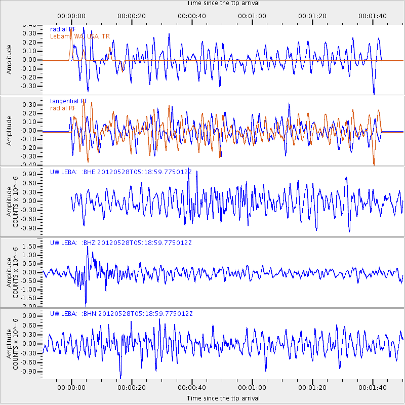
Signal To Noise
| Channel | StoN | STA | LTA |
| UW:LEBA: :BHZ:20120528T05:18:59.775012Z | 3.3306158 | 5.704573E-7 | 1.7127684E-7 |
| UW:LEBA: :BHN:20120528T05:18:59.775012Z | 1.0914054 | 2.2719453E-7 | 2.0816695E-7 |
| UW:LEBA: :BHE:20120528T05:18:59.775012Z | 1.155884 | 3.1555697E-7 | 2.7300055E-7 |
| Arrivals |
| Ps | |
| PpPs | |
| PsPs/PpSs | |


