You are here: Home > Network List > G - GEOSCOPE Stations List
> Station SCZ Chualar Canyon, Santa Cruz, California, U.S.A. > Earthquake Result Viewer
SCZ Chualar Canyon, Santa Cruz, California, U.S.A. - Earthquake Result Viewer

| Earthquake location: |
Off East Coast Of Honshu, Japan |
| Earthquake latitude/longitude: |
39.4/143.5 |
| Earthquake time(UTC): |
1992/07/29 (211) 04:30:49 GMT |
| Earthquake Depth: |
29 km |
| Earthquake Magnitude: |
5.9 MB, 6.1 MS, 6.1 UNKNOWN |
| Earthquake Catalog/Contributor: |
WHDF/NEIC |
|
| Network: |
G GEOSCOPE |
| Station: |
SCZ Chualar Canyon, Santa Cruz, California, U.S.A. |
| Lat/Lon: |
36.60 N/121.40 W |
| Elevation: |
261 m |
|
| Distance: |
71.3 deg |
| Az: |
57.811 deg |
| Baz: |
305.475 deg |
| Ray Param: |
0.054380633 |
| Estimated Moho Depth: |
20.5 km |
| Estimated Crust Vp/Vs: |
1.83 |
| Assumed Crust Vp: |
6.391 km/s |
| Estimated Crust Vs: |
3.487 km/s |
| Estimated Crust Poisson's Ratio: |
0.29 |
|
| Radial Match: |
81.799515 % |
| Radial Bump: |
400 |
| Transverse Match: |
64.68719 % |
| Transverse Bump: |
400 |
| SOD ConfigId: |
16938 |
| Insert Time: |
2010-02-26 23:47:47.178 +0000 |
| GWidth: |
2.5 |
| Max Bumps: |
400 |
| Tol: |
0.001 |
|
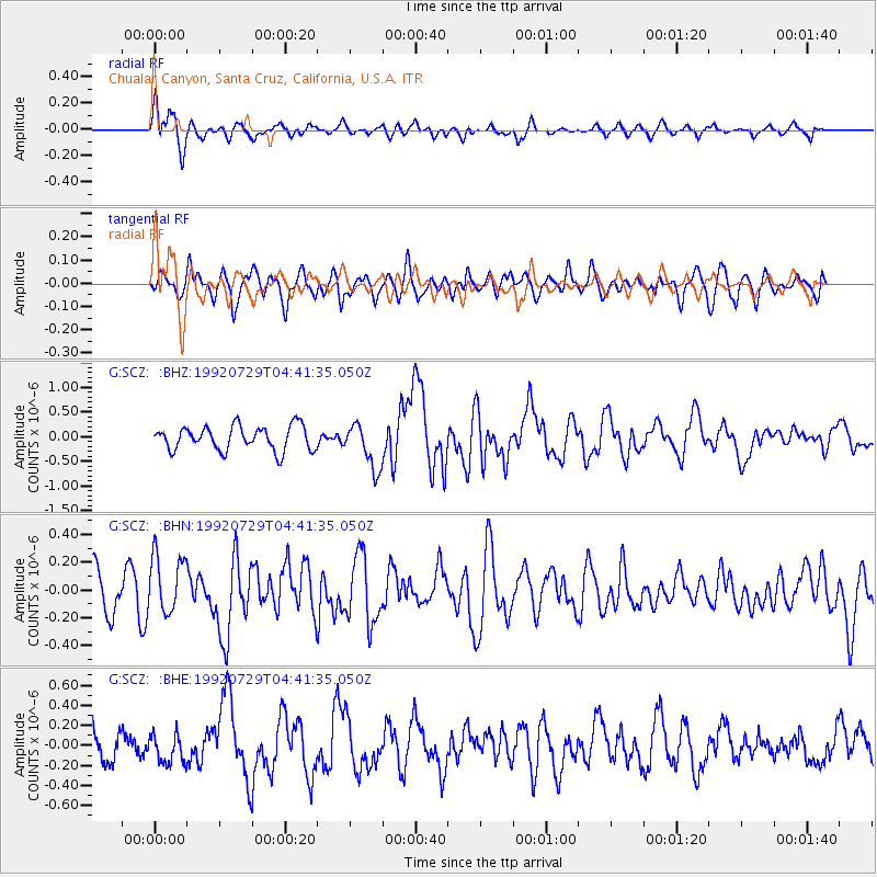
Signal To Noise
| Channel | StoN | STA | LTA |
| G:SCZ: :BHN:19920729T04:41:35.050Z | 1.6795282 | 2.1153903E-7 | 1.2595146E-7 |
| G:SCZ: :BHE:19920729T04:41:35.050Z | 1.17311 | 1.469363E-7 | 1.2525364E-7 |
| G:SCZ: :BHZ:19920729T04:41:35.050Z | 1.8855491 | 4.6163447E-7 | 2.4482762E-7 |
| Arrivals |
| Ps | 2.8 SECOND |
| PpPs | 8.8 SECOND |
| PsPs/PpSs | 12 SECOND |


