You are here: Home > Network List > G - GEOSCOPE Stations List
> Station SCZ Chualar Canyon, Santa Cruz, California, U.S.A. > Earthquake Result Viewer
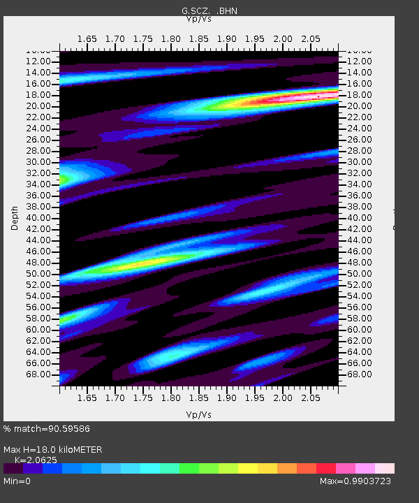
SCZ Chualar Canyon, Santa Cruz, California, U.S.A. - Earthquake Result Viewer
| Earthquake location: |
Southeast Of Honshu, Japan |
| Earthquake latitude/longitude: |
33.2/138.0 |
| Earthquake time(UTC): |
1992/08/29 (242) 19:19:07 GMT |
| Earthquake Depth: |
309 km |
| Earthquake Magnitude: |
6.0 MB |
| Earthquake Catalog/Contributor: |
WHDF/NEIC |
|
| Network: |
G GEOSCOPE |
| Station: |
SCZ Chualar Canyon, Santa Cruz, California, U.S.A. |
| Lat/Lon: |
36.60 N/121.40 W |
| Elevation: |
261 m |
|
| Distance: |
78.5 deg |
| Az: |
53.829 deg |
| Baz: |
302.705 deg |
| Ray Param: |
0.048759688 |
| Estimated Moho Depth: |
18.0 km |
| Estimated Crust Vp/Vs: |
2.06 |
| Assumed Crust Vp: |
6.391 km/s |
| Estimated Crust Vs: |
3.098 km/s |
| Estimated Crust Poisson's Ratio: |
0.35 |
|
| Radial Match: |
90.59586 % |
| Radial Bump: |
400 |
| Transverse Match: |
87.60758 % |
| Transverse Bump: |
400 |
| SOD ConfigId: |
16938 |
| Insert Time: |
2010-02-26 23:47:55.874 +0000 |
| GWidth: |
2.5 |
| Max Bumps: |
400 |
| Tol: |
0.001 |
|

Signal To Noise
| Channel | StoN | STA | LTA |
| G:SCZ: :BHN:19920829T19:30:03.799011Z | 6.9228754 | 4.924727E-7 | 7.1137016E-8 |
| G:SCZ: :BHE:19920829T19:30:03.799011Z | 12.286513 | 1.0325454E-6 | 8.403892E-8 |
| G:SCZ: :BHZ:19920829T19:30:03.799011Z | 44.39072 | 3.5346065E-6 | 7.96249E-8 |
| Arrivals |
| Ps | 3.1 SECOND |
| PpPs | 8.4 SECOND |
| PsPs/PpSs | 11 SECOND |


