You are here: Home > Network List > G - GEOSCOPE Stations List
> Station SCZ Chualar Canyon, Santa Cruz, California, U.S.A. > Earthquake Result Viewer
SCZ Chualar Canyon, Santa Cruz, California, U.S.A. - Earthquake Result Viewer

| Earthquake location: |
Hokkaido, Japan Region |
| Earthquake latitude/longitude: |
41.1/144.6 |
| Earthquake time(UTC): |
1992/05/07 (128) 06:23:40 GMT |
| Earthquake Depth: |
46 km |
| Earthquake Magnitude: |
5.8 MB, 5.7 MS |
| Earthquake Catalog/Contributor: |
WHDF/NEIC |
|
| Network: |
G GEOSCOPE |
| Station: |
SCZ Chualar Canyon, Santa Cruz, California, U.S.A. |
| Lat/Lon: |
36.60 N/121.40 W |
| Elevation: |
261 m |
|
| Distance: |
69.7 deg |
| Az: |
58.866 deg |
| Baz: |
306.524 deg |
| Ray Param: |
0.05538084 |
| Estimated Moho Depth: |
60.0 km |
| Estimated Crust Vp/Vs: |
2.08 |
| Assumed Crust Vp: |
6.391 km/s |
| Estimated Crust Vs: |
3.072 km/s |
| Estimated Crust Poisson's Ratio: |
0.35 |
|
| Radial Match: |
83.98545 % |
| Radial Bump: |
353 |
| Transverse Match: |
67.87031 % |
| Transverse Bump: |
400 |
| SOD ConfigId: |
17000 |
| Insert Time: |
2010-02-26 23:48:03.062 +0000 |
| GWidth: |
2.5 |
| Max Bumps: |
400 |
| Tol: |
0.001 |
|
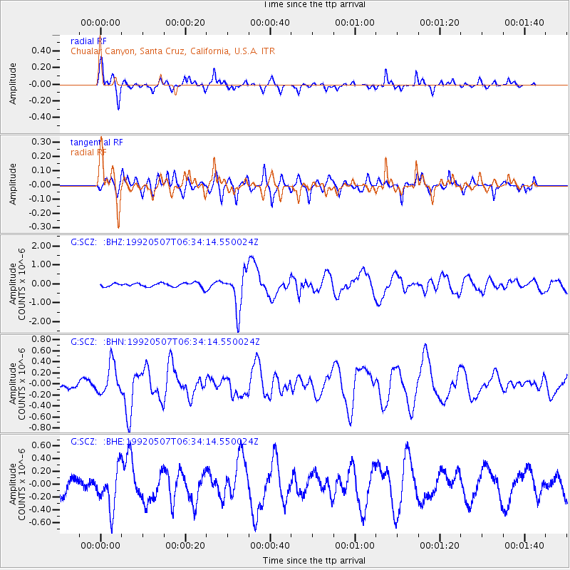
Signal To Noise
| Channel | StoN | STA | LTA |
| G:SCZ: :BHN:19920507T06:34:14.550024Z | 2.8310134 | 2.8542613E-7 | 1.0082119E-7 |
| G:SCZ: :BHE:19920507T06:34:14.550024Z | 3.0773935 | 3.2368527E-7 | 1.05181634E-7 |
| G:SCZ: :BHZ:19920507T06:34:14.550024Z | 9.690867 | 1.012625E-6 | 1.04492706E-7 |
| Arrivals |
| Ps | 10 SECOND |
| PpPs | 28 SECOND |
| PsPs/PpSs | 38 SECOND |


