You are here: Home > Network List > G - GEOSCOPE Stations List
> Station SCZ Chualar Canyon, Santa Cruz, California, U.S.A. > Earthquake Result Viewer
SCZ Chualar Canyon, Santa Cruz, California, U.S.A. - Earthquake Result Viewer
| Earthquake location: |
Hokkaido, Japan Region |
| Earthquake latitude/longitude: |
41.4/142.1 |
| Earthquake time(UTC): |
1992/07/12 (194) 11:08:56 GMT |
| Earthquake Depth: |
70 km |
| Earthquake Magnitude: |
5.9 MB |
| Earthquake Catalog/Contributor: |
WHDF/NEIC |
|
| Network: |
G GEOSCOPE |
| Station: |
SCZ Chualar Canyon, Santa Cruz, California, U.S.A. |
| Lat/Lon: |
36.60 N/121.40 W |
| Elevation: |
261 m |
|
| Distance: |
71.2 deg |
| Az: |
57.631 deg |
| Baz: |
307.902 deg |
| Ray Param: |
0.054335948 |
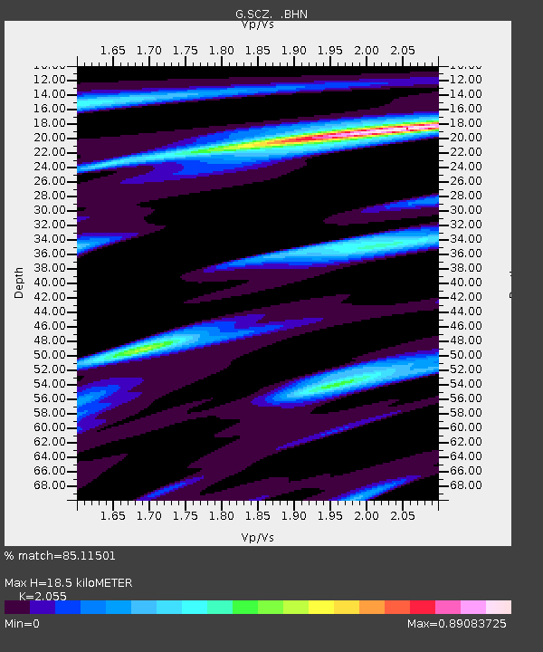
| Estimated Moho Depth: |
18.5 km |
| Estimated Crust Vp/Vs: |
2.06 |
| Assumed Crust Vp: |
6.391 km/s |
| Estimated Crust Vs: |
3.11 km/s |
| Estimated Crust Poisson's Ratio: |
0.34 |
|
| Radial Match: |
85.11501 % |
| Radial Bump: |
376 |
| Transverse Match: |
52.288795 % |
| Transverse Bump: |
350 |
| SOD ConfigId: |
17000 |
| Insert Time: |
2010-02-26 23:48:07.904 +0000 |
| GWidth: |
2.5 |
| Max Bumps: |
400 |
| Tol: |
0.001 |
|
Signal To Noise
| Channel | StoN | STA | LTA |
| G:SCZ: :BHN:19920712T11:19:36.549011Z | 1.3022568 | 3.9616265E-7 | 3.0421236E-7 |
| G:SCZ: :BHE:19920712T11:19:36.549011Z | 1.0712324 | 2.896603E-7 | 2.703991E-7 |
| G:SCZ: :BHZ:19920712T11:19:36.549011Z | 2.0022674 | 7.213137E-7 | 3.6024846E-7 |
| Arrivals |
| Ps | 3.1 SECOND |
| PpPs | 8.6 SECOND |
| PsPs/PpSs | 12 SECOND |


