You are here: Home > Network List > BK - Berkeley Digital Seismograph Network Stations List
> Station HUMO Hull Mountain, OR > Earthquake Result Viewer
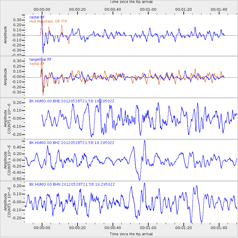
HUMO Hull Mountain, OR - Earthquake Result Viewer
*The percent match for this event was below the threshold and hence no stack was calculated.
| Earthquake location: |
Tonga Islands |
| Earthquake latitude/longitude: |
-20.0/-176.0 |
| Earthquake time(UTC): |
2012/05/28 (149) 21:47:09 GMT |
| Earthquake Depth: |
211 km |
| Earthquake Magnitude: |
5.9 MW, 5.3 MB, 5.9 MW |
| Earthquake Catalog/Contributor: |
WHDF/NEIC |
|
| Network: |
BK Berkeley Digital Seismograph Network |
| Station: |
HUMO Hull Mountain, OR |
| Lat/Lon: |
42.61 N/122.96 W |
| Elevation: |
555 m |
|
| Distance: |
79.1 deg |
| Az: |
36.911 deg |
| Baz: |
229.924 deg |
| Ray Param: |
$rayparam |
*The percent match for this event was below the threshold and hence was not used in the summary stack. |
|
| Radial Match: |
61.19782 % |
| Radial Bump: |
400 |
| Transverse Match: |
50.267803 % |
| Transverse Bump: |
400 |
| SOD ConfigId: |
455246 |
| Insert Time: |
2012-09-25 00:44:29.605 +0000 |
| GWidth: |
2.5 |
| Max Bumps: |
400 |
| Tol: |
0.001 |
|
Signal To Noise
| Channel | StoN | STA | LTA |
| BK:HUMO:00:BHZ:20120528T21:58:19.29502Z | 2.6589923 | 2.1807546E-7 | 8.2014324E-8 |
| BK:HUMO:00:BHN:20120528T21:58:19.29502Z | 1.1337609 | 6.483119E-8 | 5.718242E-8 |
| BK:HUMO:00:BHE:20120528T21:58:19.29502Z | 2.0124292 | 1.4970922E-7 | 7.439229E-8 |
| Arrivals |
| Ps | |
| PpPs | |
| PsPs/PpSs | |


