You are here: Home > Network List > G - GEOSCOPE Stations List
> Station SCZ Chualar Canyon, Santa Cruz, California, U.S.A. > Earthquake Result Viewer
SCZ Chualar Canyon, Santa Cruz, California, U.S.A. - Earthquake Result Viewer
| Earthquake location: |
Santa Cruz Islands |
| Earthquake latitude/longitude: |
-12.0/166.5 |
| Earthquake time(UTC): |
1992/08/04 (217) 21:08:44 GMT |
| Earthquake Depth: |
109 km |
| Earthquake Magnitude: |
5.9 MB |
| Earthquake Catalog/Contributor: |
WHDF/NEIC |
|
| Network: |
G GEOSCOPE |
| Station: |
SCZ Chualar Canyon, Santa Cruz, California, U.S.A. |
| Lat/Lon: |
36.60 N/121.40 W |
| Elevation: |
261 m |
|
| Distance: |
83.2 deg |
| Az: |
50.47 deg |
| Baz: |
249.664 deg |
| Ray Param: |
0.04614455 |
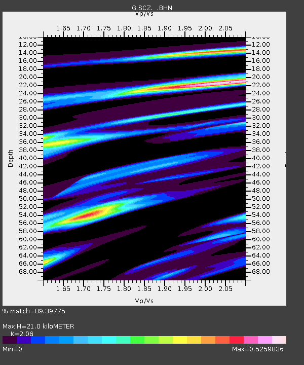
| Estimated Moho Depth: |
21.0 km |
| Estimated Crust Vp/Vs: |
2.06 |
| Assumed Crust Vp: |
6.391 km/s |
| Estimated Crust Vs: |
3.102 km/s |
| Estimated Crust Poisson's Ratio: |
0.35 |
|
| Radial Match: |
89.39775 % |
| Radial Bump: |
400 |
| Transverse Match: |
79.12491 % |
| Transverse Bump: |
400 |
| SOD ConfigId: |
17000 |
| Insert Time: |
2010-02-26 23:48:10.980 +0000 |
| GWidth: |
2.5 |
| Max Bumps: |
400 |
| Tol: |
0.001 |
|
Signal To Noise
| Channel | StoN | STA | LTA |
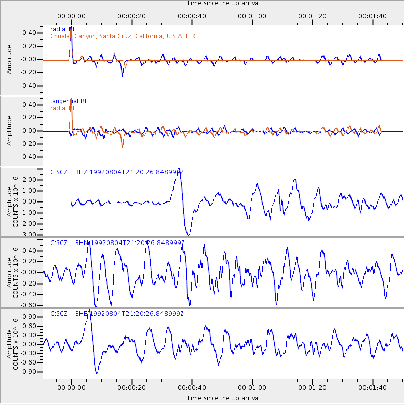
| G:SCZ: :BHN:19920804T21:20:26.848999Z | 1.3194231 | 1.17335574E-7 | 8.8929454E-8 |
| G:SCZ: :BHE:19920804T21:20:26.848999Z | 2.1450715 | 2.7867208E-7 | 1.2991273E-7 |
| G:SCZ: :BHZ:19920804T21:20:26.848999Z | 7.6391926 | 9.043474E-7 | 1.1838259E-7 |
| Arrivals |
| Ps | 3.6 SECOND |
| PpPs | 9.8 SECOND |
| PsPs/PpSs | 13 SECOND |


