You are here: Home > Network List > IW - Intermountain West Stations List
> Station IMW Indian Meadow, Wyoming, USA > Earthquake Result Viewer
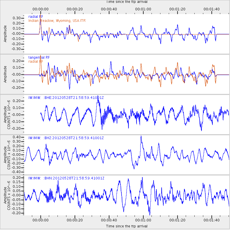
IMW Indian Meadow, Wyoming, USA - Earthquake Result Viewer
*The percent match for this event was below the threshold and hence no stack was calculated.
| Earthquake location: |
Tonga Islands |
| Earthquake latitude/longitude: |
-20.0/-176.0 |
| Earthquake time(UTC): |
2012/05/28 (149) 21:47:09 GMT |
| Earthquake Depth: |
211 km |
| Earthquake Magnitude: |
5.9 MW, 5.3 MB, 5.9 MW |
| Earthquake Catalog/Contributor: |
WHDF/NEIC |
|
| Network: |
IW Intermountain West |
| Station: |
IMW Indian Meadow, Wyoming, USA |
| Lat/Lon: |
43.90 N/110.94 W |
| Elevation: |
2646 m |
|
| Distance: |
87.0 deg |
| Az: |
41.017 deg |
| Baz: |
238.644 deg |
| Ray Param: |
$rayparam |
*The percent match for this event was below the threshold and hence was not used in the summary stack. |
|
| Radial Match: |
59.223682 % |
| Radial Bump: |
400 |
| Transverse Match: |
52.648895 % |
| Transverse Bump: |
400 |
| SOD ConfigId: |
455246 |
| Insert Time: |
2012-09-25 00:48:02.267 +0000 |
| GWidth: |
2.5 |
| Max Bumps: |
400 |
| Tol: |
0.001 |
|
Signal To Noise
| Channel | StoN | STA | LTA |
| IW:IMW: :BHZ:20120528T21:58:59.41001Z | 1.5164226 | 1.12711554E-7 | 7.4327275E-8 |
| IW:IMW: :BHN:20120528T21:58:59.41001Z | 0.89194995 | 3.9066013E-8 | 4.3798437E-8 |
| IW:IMW: :BHE:20120528T21:58:59.41001Z | 1.824231 | 1.3774934E-7 | 7.5510904E-8 |
| Arrivals |
| Ps | |
| PpPs | |
| PsPs/PpSs | |


