You are here: Home > Network List > G - GEOSCOPE Stations List
> Station SCZ Chualar Canyon, Santa Cruz, California, U.S.A. > Earthquake Result Viewer
SCZ Chualar Canyon, Santa Cruz, California, U.S.A. - Earthquake Result Viewer

| Earthquake location: |
Near Coast Of Nicaragua |
| Earthquake latitude/longitude: |
11.3/-86.8 |
| Earthquake time(UTC): |
1992/09/02 (246) 18:28:56 GMT |
| Earthquake Depth: |
10 km |
| Earthquake Magnitude: |
5.2 MB, 5.8 MS |
| Earthquake Catalog/Contributor: |
WHDF/NEIC |
|
| Network: |
G GEOSCOPE |
| Station: |
SCZ Chualar Canyon, Santa Cruz, California, U.S.A. |
| Lat/Lon: |
36.60 N/121.40 W |
| Elevation: |
261 m |
|
| Distance: |
40.1 deg |
| Az: |
314.75 deg |
| Baz: |
120.043 deg |
| Ray Param: |
0.07457899 |
| Estimated Moho Depth: |
26.25 km |
| Estimated Crust Vp/Vs: |
2.10 |
| Assumed Crust Vp: |
6.391 km/s |
| Estimated Crust Vs: |
3.05 km/s |
| Estimated Crust Poisson's Ratio: |
0.35 |
|
| Radial Match: |
88.30612 % |
| Radial Bump: |
400 |
| Transverse Match: |
68.735916 % |
| Transverse Bump: |
400 |
| SOD ConfigId: |
17000 |
| Insert Time: |
2010-02-26 23:48:14.363 +0000 |
| GWidth: |
2.5 |
| Max Bumps: |
400 |
| Tol: |
0.001 |
|
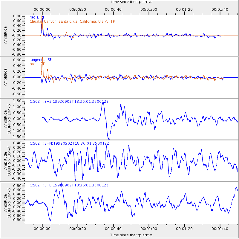
Signal To Noise
| Channel | StoN | STA | LTA |
| G:SCZ: :BHN:19920902T18:36:01.350012Z | 1.7925044 | 1.3842156E-7 | 7.722243E-8 |
| G:SCZ: :BHE:19920902T18:36:01.350012Z | 5.672193 | 3.7654266E-7 | 6.638396E-8 |
| G:SCZ: :BHZ:19920902T18:36:01.350012Z | 6.5798965 | 6.7590116E-7 | 1.0272216E-7 |
| Arrivals |
| Ps | 4.8 SECOND |
| PpPs | 12 SECOND |
| PsPs/PpSs | 17 SECOND |


