You are here: Home > Network List > TA - USArray Transportable Network (new EarthScope stations) Stations List
> Station E31A Nome, ND, USA > Earthquake Result Viewer
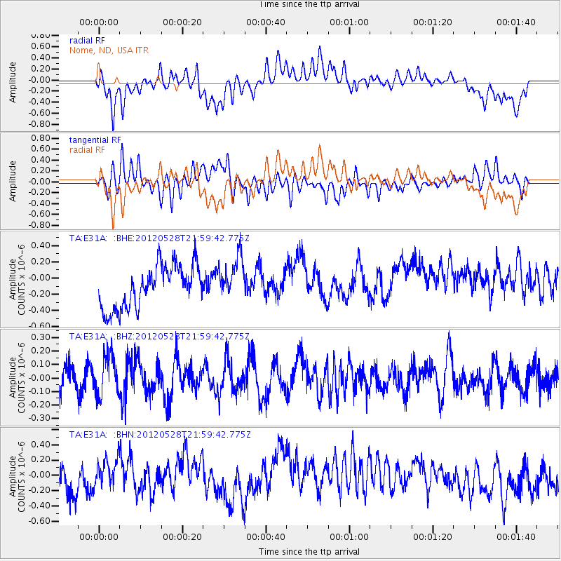
E31A Nome, ND, USA - Earthquake Result Viewer
*The percent match for this event was below the threshold and hence no stack was calculated.
| Earthquake location: |
Tonga Islands |
| Earthquake latitude/longitude: |
-20.0/-176.0 |
| Earthquake time(UTC): |
2012/05/28 (149) 21:47:09 GMT |
| Earthquake Depth: |
211 km |
| Earthquake Magnitude: |
5.9 MW, 5.3 MB, 5.9 MW |
| Earthquake Catalog/Contributor: |
WHDF/NEIC |
|
| Network: |
TA USArray Transportable Network (new EarthScope stations) |
| Station: |
E31A Nome, ND, USA |
| Lat/Lon: |
46.56 N/97.89 W |
| Elevation: |
427 m |
|
| Distance: |
96.4 deg |
| Az: |
42.8 deg |
| Baz: |
247.848 deg |
| Ray Param: |
$rayparam |
*The percent match for this event was below the threshold and hence was not used in the summary stack. |
|
| Radial Match: |
41.940674 % |
| Radial Bump: |
400 |
| Transverse Match: |
43.448326 % |
| Transverse Bump: |
400 |
| SOD ConfigId: |
455246 |
| Insert Time: |
2012-09-25 00:50:47.268 +0000 |
| GWidth: |
2.5 |
| Max Bumps: |
400 |
| Tol: |
0.001 |
|
Signal To Noise
| Channel | StoN | STA | LTA |
| TA:E31A: :BHZ:20120528T21:59:42.775Z | 1.6744646 | 1.5177272E-7 | 9.063956E-8 |
| TA:E31A: :BHN:20120528T21:59:42.775Z | 1.532136 | 2.1603731E-7 | 1.4100401E-7 |
| TA:E31A: :BHE:20120528T21:59:42.775Z | 1.0351396 | 2.6837677E-7 | 2.5926627E-7 |
| Arrivals |
| Ps | |
| PpPs | |
| PsPs/PpSs | |


