You are here: Home > Network List > TA - USArray Transportable Network (new EarthScope stations) Stations List
> Station H63A New Sharon, ME, USA > Earthquake Result Viewer
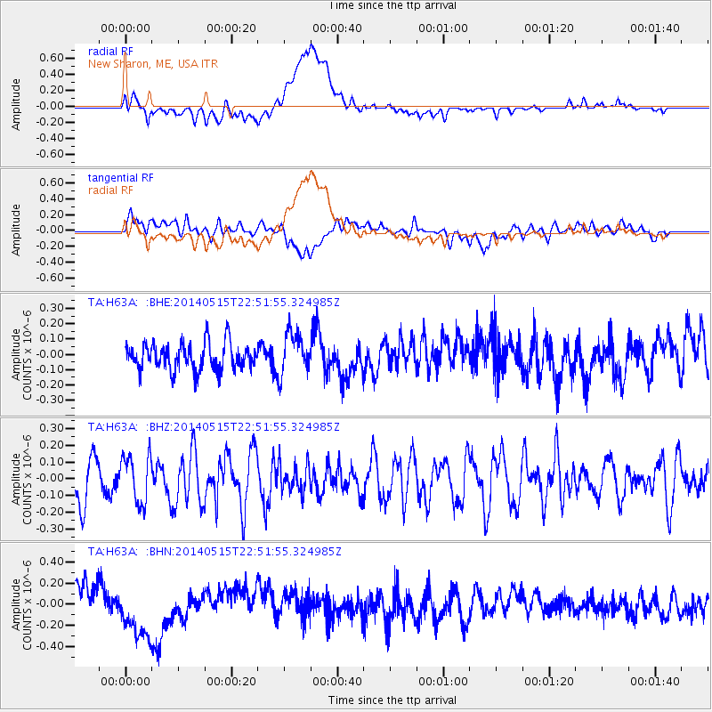
H63A New Sharon, ME, USA - Earthquake Result Viewer
*The percent match for this event was below the threshold and hence no stack was calculated.
| Earthquake location: |
Near Coast Of Northern Peru |
| Earthquake latitude/longitude: |
-7.7/-79.5 |
| Earthquake time(UTC): |
2014/05/15 (135) 22:43:17 GMT |
| Earthquake Depth: |
62 km |
| Earthquake Magnitude: |
5.0 MW |
| Earthquake Catalog/Contributor: |
ISC/ISC |
|
| Network: |
TA USArray Transportable Network (new EarthScope stations) |
| Station: |
H63A New Sharon, ME, USA |
| Lat/Lon: |
44.66 N/70.04 W |
| Elevation: |
109 m |
|
| Distance: |
52.8 deg |
| Az: |
8.442 deg |
| Baz: |
191.765 deg |
| Ray Param: |
$rayparam |
*The percent match for this event was below the threshold and hence was not used in the summary stack. |
|
| Radial Match: |
41.860172 % |
| Radial Bump: |
400 |
| Transverse Match: |
53.971985 % |
| Transverse Bump: |
400 |
| SOD ConfigId: |
3390531 |
| Insert Time: |
2019-04-11 21:49:50.263 +0000 |
| GWidth: |
2.5 |
| Max Bumps: |
400 |
| Tol: |
0.001 |
|
Signal To Noise
| Channel | StoN | STA | LTA |
| TA:H63A: :BHZ:20140515T22:51:55.324985Z | 0.8821489 | 1.4317835E-7 | 1.6230632E-7 |
| TA:H63A: :BHN:20140515T22:51:55.324985Z | 2.2847958 | 2.8479153E-7 | 1.2464639E-7 |
| TA:H63A: :BHE:20140515T22:51:55.324985Z | 1.533643 | 1.3616062E-7 | 8.878248E-8 |
| Arrivals |
| Ps | |
| PpPs | |
| PsPs/PpSs | |


