You are here: Home > Network List > G - GEOSCOPE Stations List
> Station SCZ Chualar Canyon, Santa Cruz, California, U.S.A. > Earthquake Result Viewer
SCZ Chualar Canyon, Santa Cruz, California, U.S.A. - Earthquake Result Viewer
| Earthquake location: |
Near East Coast Of Kamchatka |
| Earthquake latitude/longitude: |
51.9/158.7 |
| Earthquake time(UTC): |
1993/11/13 (317) 01:18:04 GMT |
| Earthquake Depth: |
34 km |
| Earthquake Magnitude: |
6.5 MB, 7.1 MS, 6.9 UNKNOWN |
| Earthquake Catalog/Contributor: |
WHDF/NEIC |
|
| Network: |
G GEOSCOPE |
| Station: |
SCZ Chualar Canyon, Santa Cruz, California, U.S.A. |
| Lat/Lon: |
36.60 N/121.40 W |
| Elevation: |
261 m |
|
| Distance: |
56.4 deg |
| Az: |
72.042 deg |
| Baz: |
312.936 deg |
| Ray Param: |
0.06411122 |
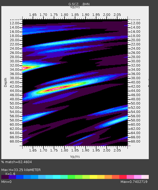
| Estimated Moho Depth: |
33.25 km |
| Estimated Crust Vp/Vs: |
1.60 |
| Assumed Crust Vp: |
6.391 km/s |
| Estimated Crust Vs: |
3.994 km/s |
| Estimated Crust Poisson's Ratio: |
0.18 |
|
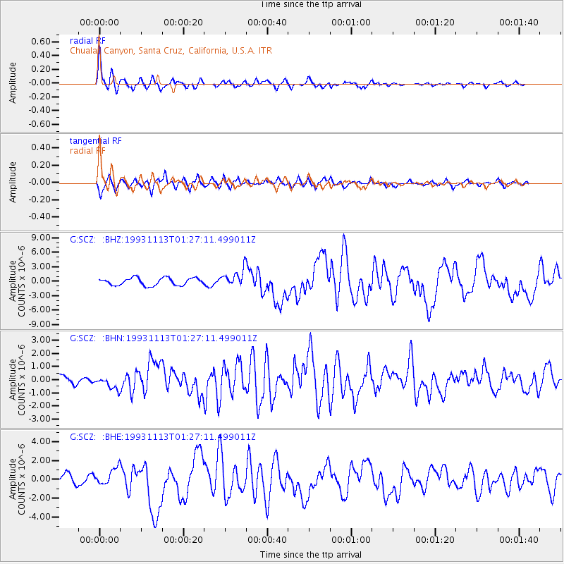
| Radial Match: |
82.4604 % |
| Radial Bump: |
303 |
| Transverse Match: |
69.02175 % |
| Transverse Bump: |
386 |
| SOD ConfigId: |
16938 |
| Insert Time: |
2010-02-26 23:48:23.204 +0000 |
| GWidth: |
2.5 |
| Max Bumps: |
400 |
| Tol: |
0.001 |
|
Signal To Noise
| Channel | StoN | STA | LTA |
| G:SCZ: :BHN:19931113T01:27:11.499011Z | 1.0891722 | 4.891773E-7 | 4.4912758E-7 |
| G:SCZ: :BHE:19931113T01:27:11.499011Z | 1.041439 | 9.263764E-7 | 8.8951566E-7 |
| G:SCZ: :BHZ:19931113T01:27:11.499011Z | 2.3489504 | 1.7908615E-6 | 7.6240923E-7 |
| Arrivals |
| Ps | 3.3 SECOND |
| PpPs | 13 SECOND |
| PsPs/PpSs | 16 SECOND |


