You are here: Home > Network List > G - GEOSCOPE Stations List
> Station SCZ Chualar Canyon, Santa Cruz, California, U.S.A. > Earthquake Result Viewer
SCZ Chualar Canyon, Santa Cruz, California, U.S.A. - Earthquake Result Viewer
| Earthquake location: |
Alaska Peninsula |
| Earthquake latitude/longitude: |
55.2/-160.5 |
| Earthquake time(UTC): |
1993/05/13 (133) 11:59:49 GMT |
| Earthquake Depth: |
32 km |
| Earthquake Magnitude: |
6.4 MB, 6.8 MS, 6.8 UNKNOWN |
| Earthquake Catalog/Contributor: |
WHDF/NEIC |
|
| Network: |
G GEOSCOPE |
| Station: |
SCZ Chualar Canyon, Santa Cruz, California, U.S.A. |
| Lat/Lon: |
36.60 N/121.40 W |
| Elevation: |
261 m |
|
| Distance: |
32.4 deg |
| Az: |
108.674 deg |
| Baz: |
317.524 deg |
| Ray Param: |
0.0786381 |
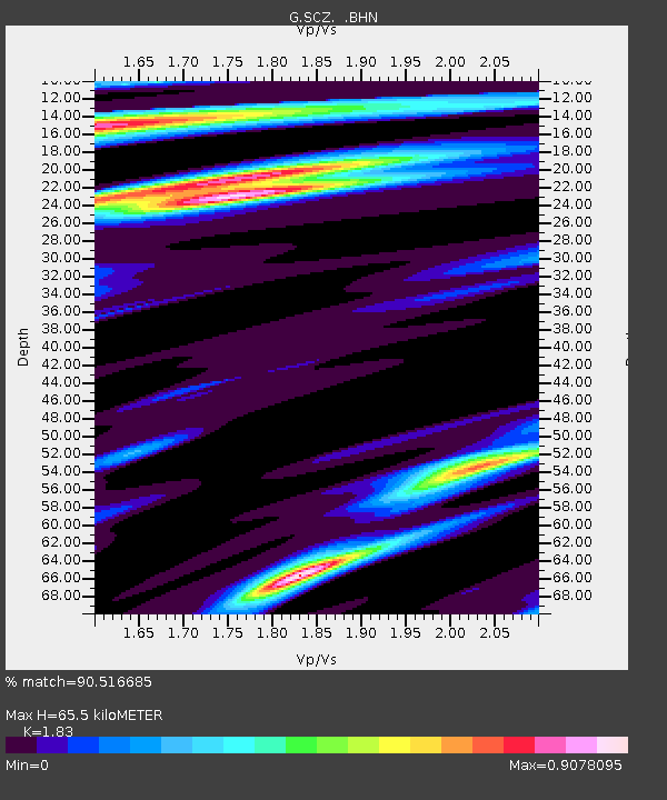
| Estimated Moho Depth: |
65.5 km |
| Estimated Crust Vp/Vs: |
1.83 |
| Assumed Crust Vp: |
6.391 km/s |
| Estimated Crust Vs: |
3.492 km/s |
| Estimated Crust Poisson's Ratio: |
0.29 |
|
| Radial Match: |
90.516685 % |
| Radial Bump: |
344 |
| Transverse Match: |
76.77407 % |
| Transverse Bump: |
400 |
| SOD ConfigId: |
16938 |
| Insert Time: |
2010-02-26 23:48:26.564 +0000 |
| GWidth: |
2.5 |
| Max Bumps: |
400 |
| Tol: |
0.001 |
|
Signal To Noise
| Channel | StoN | STA | LTA |
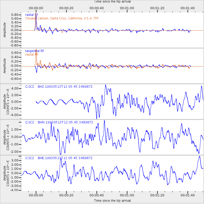
| G:SCZ: :BHN:19930513T12:05:45.348987Z | 2.3613794 | 5.049918E-7 | 2.1385459E-7 |
| G:SCZ: :BHE:19930513T12:05:45.348987Z | 2.2311227 | 7.165592E-7 | 3.2116532E-7 |
| G:SCZ: :BHZ:19930513T12:05:45.348987Z | 2.700263 | 1.3206632E-6 | 4.8908686E-7 |
| Arrivals |
| Ps | 9.2 SECOND |
| PpPs | 27 SECOND |
| PsPs/PpSs | 36 SECOND |


