You are here: Home > Network List > TA - USArray Transportable Network (new EarthScope stations) Stations List
> Station V56A Mocksville, NC, USA > Earthquake Result Viewer
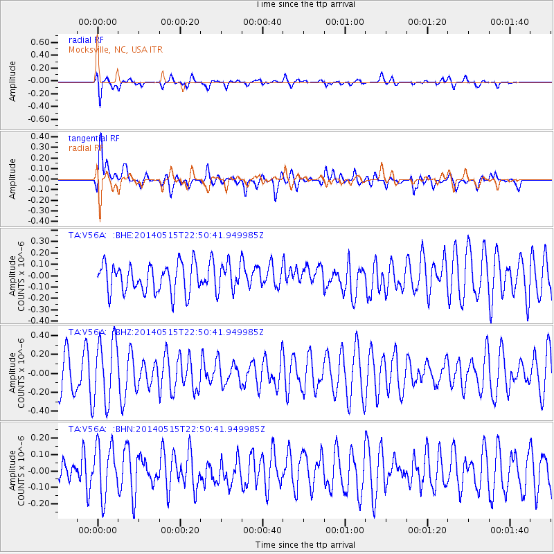
V56A Mocksville, NC, USA - Earthquake Result Viewer
*The percent match for this event was below the threshold and hence no stack was calculated.
| Earthquake location: |
Near Coast Of Northern Peru |
| Earthquake latitude/longitude: |
-7.7/-79.5 |
| Earthquake time(UTC): |
2014/05/15 (135) 22:43:17 GMT |
| Earthquake Depth: |
62 km |
| Earthquake Magnitude: |
5.0 MW |
| Earthquake Catalog/Contributor: |
ISC/ISC |
|
| Network: |
TA USArray Transportable Network (new EarthScope stations) |
| Station: |
V56A Mocksville, NC, USA |
| Lat/Lon: |
35.81 N/80.50 W |
| Elevation: |
237 m |
|
| Distance: |
43.3 deg |
| Az: |
358.774 deg |
| Baz: |
178.505 deg |
| Ray Param: |
$rayparam |
*The percent match for this event was below the threshold and hence was not used in the summary stack. |
|
| Radial Match: |
66.25475 % |
| Radial Bump: |
400 |
| Transverse Match: |
61.800312 % |
| Transverse Bump: |
400 |
| SOD ConfigId: |
3390531 |
| Insert Time: |
2019-04-11 21:50:34.035 +0000 |
| GWidth: |
2.5 |
| Max Bumps: |
400 |
| Tol: |
0.001 |
|
Signal To Noise
| Channel | StoN | STA | LTA |
| TA:V56A: :BHZ:20140515T22:50:41.949985Z | 1.856986 | 3.3273824E-7 | 1.7918187E-7 |
| TA:V56A: :BHN:20140515T22:50:41.949985Z | 1.5252358 | 1.6208912E-7 | 1.0627152E-7 |
| TA:V56A: :BHE:20140515T22:50:41.949985Z | 0.9731767 | 1.2180003E-7 | 1.2515716E-7 |
| Arrivals |
| Ps | |
| PpPs | |
| PsPs/PpSs | |


