You are here: Home > Network List > G - GEOSCOPE Stations List
> Station SCZ Chualar Canyon, Santa Cruz, California, U.S.A. > Earthquake Result Viewer
SCZ Chualar Canyon, Santa Cruz, California, U.S.A. - Earthquake Result Viewer
| Earthquake location: |
Andreanof Islands, Aleutian Is. |
| Earthquake latitude/longitude: |
51.3/-178.7 |
| Earthquake time(UTC): |
1993/05/15 (135) 21:52:25 GMT |
| Earthquake Depth: |
33 km |
| Earthquake Magnitude: |
6.2 MB, 6.5 MS, 6.3 UNKNOWN, 6.1 ML |
| Earthquake Catalog/Contributor: |
WHDF/NEIC |
|
| Network: |
G GEOSCOPE |
| Station: |
SCZ Chualar Canyon, Santa Cruz, California, U.S.A. |
| Lat/Lon: |
36.60 N/121.40 W |
| Elevation: |
261 m |
|
| Distance: |
42.7 deg |
| Az: |
87.179 deg |
| Baz: |
308.877 deg |
| Ray Param: |
0.07297653 |
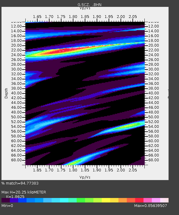
| Estimated Moho Depth: |
20.25 km |
| Estimated Crust Vp/Vs: |
1.86 |
| Assumed Crust Vp: |
6.391 km/s |
| Estimated Crust Vs: |
3.431 km/s |
| Estimated Crust Poisson's Ratio: |
0.30 |
|
| Radial Match: |
94.77383 % |
| Radial Bump: |
379 |
| Transverse Match: |
88.13368 % |
| Transverse Bump: |
400 |
| SOD ConfigId: |
16938 |
| Insert Time: |
2010-02-26 23:48:31.974 +0000 |
| GWidth: |
2.5 |
| Max Bumps: |
400 |
| Tol: |
0.001 |
|
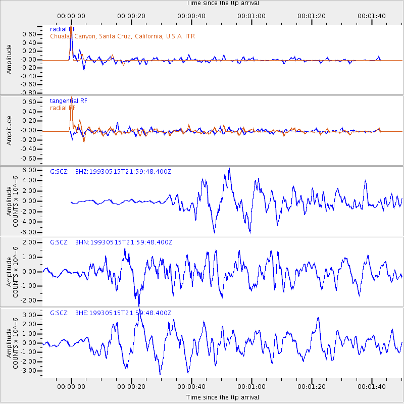
Signal To Noise
| Channel | StoN | STA | LTA |
| G:SCZ: :BHN:19930515T21:59:48.400Z | 0.9510797 | 1.1751311E-7 | 1.2355758E-7 |
| G:SCZ: :BHE:19930515T21:59:48.400Z | 2.1412308 | 3.1116085E-7 | 1.453187E-7 |
| G:SCZ: :BHZ:19930515T21:59:48.400Z | 2.1487288 | 5.53369E-7 | 2.5753317E-7 |
| Arrivals |
| Ps | 2.9 SECOND |
| PpPs | 8.5 SECOND |
| PsPs/PpSs | 11 SECOND |


