You are here: Home > Network List > G - GEOSCOPE Stations List
> Station SCZ Chualar Canyon, Santa Cruz, California, U.S.A. > Earthquake Result Viewer
SCZ Chualar Canyon, Santa Cruz, California, U.S.A. - Earthquake Result Viewer
| Earthquake location: |
Mariana Islands |
| Earthquake latitude/longitude: |
13.1/145.6 |
| Earthquake time(UTC): |
1993/08/11 (223) 14:17:41 GMT |
| Earthquake Depth: |
56 km |
| Earthquake Magnitude: |
6.0 MB, 6.2 MS, 6.1 UNKNOWN, 6.2 MW |
| Earthquake Catalog/Contributor: |
WHDF/NEIC |
|
| Network: |
G GEOSCOPE |
| Station: |
SCZ Chualar Canyon, Santa Cruz, California, U.S.A. |
| Lat/Lon: |
36.60 N/121.40 W |
| Elevation: |
261 m |
|
| Distance: |
84.7 deg |
| Az: |
53.821 deg |
| Baz: |
282.276 deg |
| Ray Param: |
0.045229014 |
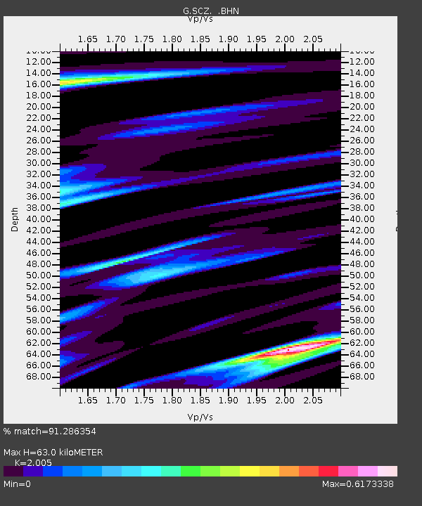
| Estimated Moho Depth: |
63.0 km |
| Estimated Crust Vp/Vs: |
2.01 |
| Assumed Crust Vp: |
6.391 km/s |
| Estimated Crust Vs: |
3.187 km/s |
| Estimated Crust Poisson's Ratio: |
0.33 |
|
| Radial Match: |
91.286354 % |
| Radial Bump: |
391 |
| Transverse Match: |
87.30626 % |
| Transverse Bump: |
400 |
| SOD ConfigId: |
16938 |
| Insert Time: |
2010-02-26 23:48:48.083 +0000 |
| GWidth: |
2.5 |
| Max Bumps: |
400 |
| Tol: |
0.001 |
|

Signal To Noise
| Channel | StoN | STA | LTA |
| G:SCZ: :BHN:19930811T14:29:38.200Z | 0.68262184 | 5.1045568E-8 | 7.477869E-8 |
| G:SCZ: :BHE:19930811T14:29:38.200Z | 1.7996906 | 1.6359034E-7 | 9.089915E-8 |
| G:SCZ: :BHZ:19930811T14:29:38.200Z | 3.2162008 | 2.9292687E-7 | 9.107854E-8 |
| Arrivals |
| Ps | 10 SECOND |
| PpPs | 29 SECOND |
| PsPs/PpSs | 39 SECOND |


