You are here: Home > Network List > G - GEOSCOPE Stations List
> Station SCZ Chualar Canyon, Santa Cruz, California, U.S.A. > Earthquake Result Viewer
SCZ Chualar Canyon, Santa Cruz, California, U.S.A. - Earthquake Result Viewer
| Earthquake location: |
Southeast Of Honshu, Japan |
| Earthquake latitude/longitude: |
32.0/137.9 |
| Earthquake time(UTC): |
1993/10/11 (284) 15:54:22 GMT |
| Earthquake Depth: |
365 km |
| Earthquake Magnitude: |
6.5 MB, 6.8 UNKNOWN, 6.9 MW |
| Earthquake Catalog/Contributor: |
WHDF/NEIC |
|
| Network: |
G GEOSCOPE |
| Station: |
SCZ Chualar Canyon, Santa Cruz, California, U.S.A. |
| Lat/Lon: |
36.60 N/121.40 W |
| Elevation: |
261 m |
|
| Distance: |
79.3 deg |
| Az: |
53.574 deg |
| Baz: |
301.845 deg |
| Ray Param: |
0.048051607 |
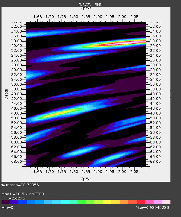
| Estimated Moho Depth: |
18.5 km |
| Estimated Crust Vp/Vs: |
2.03 |
| Assumed Crust Vp: |
6.391 km/s |
| Estimated Crust Vs: |
3.152 km/s |
| Estimated Crust Poisson's Ratio: |
0.34 |
|
| Radial Match: |
90.73856 % |
| Radial Bump: |
400 |
| Transverse Match: |
82.50591 % |
| Transverse Bump: |
400 |
| SOD ConfigId: |
16938 |
| Insert Time: |
2010-02-26 23:49:03.210 +0000 |
| GWidth: |
2.5 |
| Max Bumps: |
400 |
| Tol: |
0.001 |
|
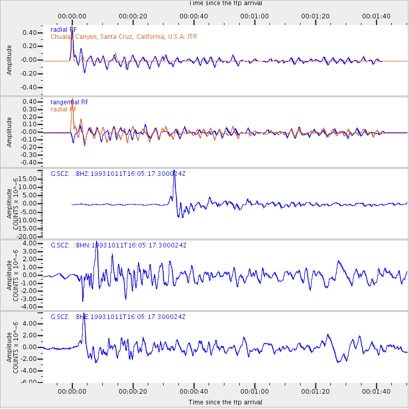
Signal To Noise
| Channel | StoN | STA | LTA |
| G:SCZ: :BHN:19931011T16:05:17.300024Z | 5.8089814 | 8.099443E-7 | 1.3942966E-7 |
| G:SCZ: :BHE:19931011T16:05:17.300024Z | 9.198658 | 2.0394498E-6 | 2.2171166E-7 |
| G:SCZ: :BHZ:19931011T16:05:17.300024Z | 30.351746 | 6.7581427E-6 | 2.2266074E-7 |
| Arrivals |
| Ps | 3.0 SECOND |
| PpPs | 8.6 SECOND |
| PsPs/PpSs | 12 SECOND |


