You are here: Home > Network List > G - GEOSCOPE Stations List
> Station SCZ Chualar Canyon, Santa Cruz, California, U.S.A. > Earthquake Result Viewer
SCZ Chualar Canyon, Santa Cruz, California, U.S.A. - Earthquake Result Viewer

| Earthquake location: |
Andreanof Islands, Aleutian Is. |
| Earthquake latitude/longitude: |
50.2/-177.4 |
| Earthquake time(UTC): |
1993/11/11 (315) 00:28:34 GMT |
| Earthquake Depth: |
23 km |
| Earthquake Magnitude: |
6.3 MB, 5.7 MS, 6.0 UNKNOWN, 5.9 ML |
| Earthquake Catalog/Contributor: |
WHDF/NEIC |
|
| Network: |
G GEOSCOPE |
| Station: |
SCZ Chualar Canyon, Santa Cruz, California, U.S.A. |
| Lat/Lon: |
36.60 N/121.40 W |
| Elevation: |
261 m |
|
| Distance: |
41.9 deg |
| Az: |
86.858 deg |
| Baz: |
307.16 deg |
| Ray Param: |
0.07343373 |
| Estimated Moho Depth: |
31.0 km |
| Estimated Crust Vp/Vs: |
1.61 |
| Assumed Crust Vp: |
6.391 km/s |
| Estimated Crust Vs: |
3.976 km/s |
| Estimated Crust Poisson's Ratio: |
0.18 |
|
| Radial Match: |
82.68566 % |
| Radial Bump: |
400 |
| Transverse Match: |
76.71539 % |
| Transverse Bump: |
400 |
| SOD ConfigId: |
16938 |
| Insert Time: |
2010-02-26 23:49:04.998 +0000 |
| GWidth: |
2.5 |
| Max Bumps: |
400 |
| Tol: |
0.001 |
|
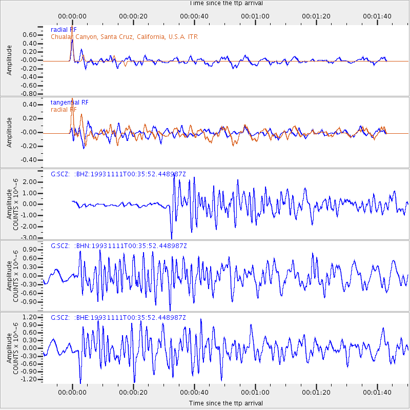
Signal To Noise
| Channel | StoN | STA | LTA |
| G:SCZ: :BHN:19931111T00:35:52.448987Z | 1.4472455 | 3.2098984E-7 | 2.2179366E-7 |
| G:SCZ: :BHE:19931111T00:35:52.448987Z | 2.6034267 | 4.6874746E-7 | 1.8005018E-7 |
| G:SCZ: :BHZ:19931111T00:35:52.448987Z | 9.572141 | 1.1775373E-6 | 1.2301714E-7 |
| Arrivals |
| Ps | 3.2 SECOND |
| PpPs | 12 SECOND |
| PsPs/PpSs | 15 SECOND |


