You are here: Home > Network List > G - GEOSCOPE Stations List
> Station SCZ Chualar Canyon, Santa Cruz, California, U.S.A. > Earthquake Result Viewer
SCZ Chualar Canyon, Santa Cruz, California, U.S.A. - Earthquake Result Viewer

| Earthquake location: |
Unimak Island Region, Alaska |
| Earthquake latitude/longitude: |
54.3/-164.2 |
| Earthquake time(UTC): |
1993/11/19 (323) 01:43:23 GMT |
| Earthquake Depth: |
31 km |
| Earthquake Magnitude: |
6.2 MB, 6.3 MS |
| Earthquake Catalog/Contributor: |
WHDF/NEIC |
|
| Network: |
G GEOSCOPE |
| Station: |
SCZ Chualar Canyon, Santa Cruz, California, U.S.A. |
| Lat/Lon: |
36.60 N/121.40 W |
| Elevation: |
261 m |
|
| Distance: |
34.2 deg |
| Az: |
103.403 deg |
| Baz: |
314.854 deg |
| Ray Param: |
0.07781389 |
| Estimated Moho Depth: |
24.25 km |
| Estimated Crust Vp/Vs: |
1.64 |
| Assumed Crust Vp: |
6.391 km/s |
| Estimated Crust Vs: |
3.885 km/s |
| Estimated Crust Poisson's Ratio: |
0.21 |
|
| Radial Match: |
88.3188 % |
| Radial Bump: |
301 |
| Transverse Match: |
80.34772 % |
| Transverse Bump: |
400 |
| SOD ConfigId: |
16938 |
| Insert Time: |
2010-02-26 23:49:06.793 +0000 |
| GWidth: |
2.5 |
| Max Bumps: |
400 |
| Tol: |
0.001 |
|
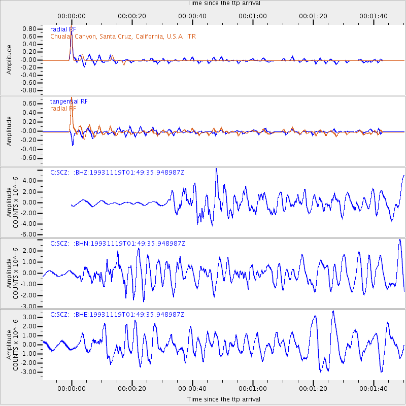
Signal To Noise
| Channel | StoN | STA | LTA |
| G:SCZ: :BHN:19931119T01:49:35.948987Z | 1.7468712 | 3.3494888E-7 | 1.9174217E-7 |
| G:SCZ: :BHE:19931119T01:49:35.948987Z | 2.5719573 | 5.6995884E-7 | 2.216051E-7 |
| G:SCZ: :BHZ:19931119T01:49:35.948987Z | 3.6764915 | 1.0676598E-6 | 2.904018E-7 |
| Arrivals |
| Ps | 2.7 SECOND |
| PpPs | 9.2 SECOND |
| PsPs/PpSs | 12 SECOND |


