You are here: Home > Network List > G - GEOSCOPE Stations List
> Station SCZ Chualar Canyon, Santa Cruz, California, U.S.A. > Earthquake Result Viewer
SCZ Chualar Canyon, Santa Cruz, California, U.S.A. - Earthquake Result Viewer

| Earthquake location: |
Peru-Bolivia Border Region |
| Earthquake latitude/longitude: |
-13.3/-69.4 |
| Earthquake time(UTC): |
1994/01/10 (010) 15:53:49 GMT |
| Earthquake Depth: |
589 km |
| Earthquake Magnitude: |
6.4 MB, 6.4 UNKNOWN, 6.9 MW |
| Earthquake Catalog/Contributor: |
WHDF/NEIC |
|
| Network: |
G GEOSCOPE |
| Station: |
SCZ Chualar Canyon, Santa Cruz, California, U.S.A. |
| Lat/Lon: |
36.60 N/121.40 W |
| Elevation: |
261 m |
|
| Distance: |
69.7 deg |
| Az: |
317.457 deg |
| Baz: |
125.124 deg |
| Ray Param: |
0.053395454 |
| Estimated Moho Depth: |
28.25 km |
| Estimated Crust Vp/Vs: |
1.62 |
| Assumed Crust Vp: |
6.391 km/s |
| Estimated Crust Vs: |
3.945 km/s |
| Estimated Crust Poisson's Ratio: |
0.19 |
|
| Radial Match: |
92.91692 % |
| Radial Bump: |
400 |
| Transverse Match: |
86.12945 % |
| Transverse Bump: |
400 |
| SOD ConfigId: |
16938 |
| Insert Time: |
2010-02-26 23:49:08.133 +0000 |
| GWidth: |
2.5 |
| Max Bumps: |
400 |
| Tol: |
0.001 |
|
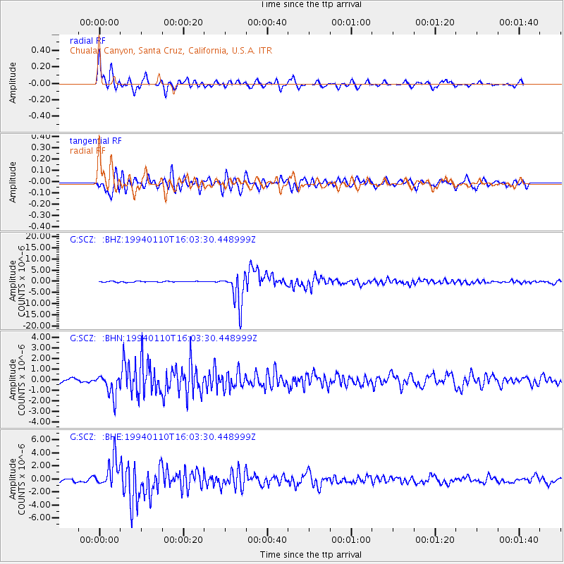
Signal To Noise
| Channel | StoN | STA | LTA |
| G:SCZ: :BHN:19940110T16:03:30.448999Z | 5.137698 | 1.0943048E-6 | 2.1299515E-7 |
| G:SCZ: :BHE:19940110T16:03:30.448999Z | 12.177087 | 2.276806E-6 | 1.8697462E-7 |
| G:SCZ: :BHZ:19940110T16:03:30.448999Z | 37.04081 | 7.457246E-6 | 2.0132514E-7 |
| Arrivals |
| Ps | 2.8 SECOND |
| PpPs | 11 SECOND |
| PsPs/PpSs | 14 SECOND |


